Artova geodata
Artova (Tokat) is a seat of a second-order administrative division; located in Turkey in Europe/Istanbul (GMT+3) time zone. With population of 6,231 people, there are 646 cities with bigger population in this country. Compared to other cities in Turkey, 71.1% of cities are located further ↓South; 53.5% of cities are located further ←West and 79.5% of cities have lower elevation than Artova. Note1


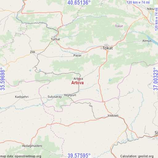
Artova GPS coordinates[2]
40° 6' 56.808" North, 36° 18' 0.36" East
| Map corner | latitude | longitude |
|---|---|---|
| Upper-left | 40.65136°, | 35.59698° |
| Center: | 40.11578°, | 36.3001° |
| Lower-right: | 39.57595°, | 37.00323° |
| Map W x H: | 119.6×119.6 km | = 74.3×74.3mi |
| max Lat: | 42.02683° ⇑28.9% North |
| Artova: | 40.11578° |
| min Lat: | ⇓71.1% South 35.9025° |
| min Long | Artova | max Long |
| 25.90902° | 36.3001° | 44.60099° |
| W 53.5%⇐ | ⇒46.5% E |
Elevation
Elevation of Artova is 1182 m = 3878 ft, and this is 464.6 m = 1524 ft above average elevation for this country.
| Max E: |
2682 m = 8799 ft | 20.5% |
| Artova | 1182 m 3878 ft | |
| Avg. | 717.4 m = 2354 ft | |
Min E: |
0 m = 0 ft | 79.5% |
See also: Turkey elevation on elevation.city.
Geographical zone
Artova is located in North temperate zone (between Tropic of Cancer and the Arctic Circle). Distance of this Northern Tropic circle is 1854.5 km =1152.3 mi to South.| Distance of | km | miles | from Artova |
|---|---|---|---|
| North Pole | 5546.6 | 3446.5 | to North |
| Arctic Circle | 2940.7 | 1827.3 | to North |
| Tropic Cancer | 1854.5 | 1152.3 | to South |
| Equator | 4460.5 | 2771.6 | to South |


Nearby cities:
15 places around Artova: (largest is in red/bold)
• Boztepe
36 km =22.4 mi,  282°
282°
• Dökmetepe
21.9 km =13.6 mi,  358°
358°
• Ezinepazarı
52.3 km =32.5 mi,  344°
344°
• Kadışehri
45.3 km =28.1 mi,  252°
252°
• Pazar
17.9 km =11.1 mi, 355°
• Sulusaray
22.8 km =14.2 mi,  233°
233°
• Tokat
30.8 km =19.1 mi,  44°
44°
• Turhal
35.5 km =22.1 mi,  328°
328°
• Yavu
36.9 km =22.9 mi,  192°
192°
• Yeşilyurt
13.9 km =8.6 mi,  209°
209°
• Yeşilyurt
24 km =14.9 mi,  10°
10°
• Yıldızeli
37.6 km =23.4 mi,  137°
137°
• Zile
40.8 km =25.4 mi,  300°
300°
• Çamlıbel
15.4 km =9.6 mi,  102°
102°
• Çırçır
41 km =25.5 mi, 99°
Sources, notices
• [Note1] Compared only with cities in Turkey existing in our database
• [Src1] Map data: © OpenStreetMap contributors (CC-BY-SA)
• [Src2] Other city data from geonames.org with taken over terms of usage.
• [Src3] Geographical zone / Annual Mean Temperature by Robert A. Rohde @ Wikipedia
