Göynücek geodata
Göynücek (Amasya) is a seat of a second-order administrative division; located in Turkey in Europe/Istanbul (GMT+3) time zone. With population of 2,796 people, there are 872 cities with bigger population in this country. Compared to other cities in Turkey, 76% of cities are located further ↓South; 51.9% of cities are located further →East and 58.9% of cities have higher elevation than Göynücek. Note1


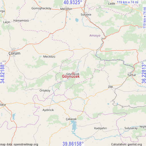
Göynücek GPS coordinates[2]
40° 23' 57.012" North, 35° 31' 30" East
| Map corner | latitude | longitude |
|---|---|---|
| Upper-left | 40.9325°, | 34.82188° |
| Center: | 40.39917°, | 35.525° |
| Lower-right: | 39.86158°, | 36.22813° |
| Map W x H: | 119.1×119.1 km | = 74×74mi |
| max Lat: | 42.02683° ⇑24% North |
| Göynücek: | 40.39917° |
| min Lat: | ⇓76% South 35.9025° |
| min Long | Göynücek | max Long |
| 25.90902° | 35.525° | 44.60099° |
| W 48.1%⇐ | ⇒51.9% E |
Elevation
Elevation of Göynücek is 524 m = 1719 ft, and this is 193.4 m = 635 ft below average elevation for this country.
| Max E: |
2682 m = 8799 ft | 58.9% |
| Avg. | 717.4 m = 2354 ft | |
| Göynücek | 524 m = 1719 ft | |
Min E: |
0 m = 0 ft | 41.1% |
See also: Turkey elevation on elevation.city.
Geographical zone
Göynücek is located in North temperate zone (between Tropic of Cancer and the Arctic Circle). Distance of this Northern Tropic circle is 1886 km =1171.9 mi to South.| Distance of | km | miles | from Göynücek |
|---|---|---|---|
| North Pole | 5515.1 | 3426.9 | to North |
| Arctic Circle | 2909.2 | 1807.7 | to North |
| Tropic Cancer | 1886 | 1171.9 | to South |
| Equator | 4492 | 2791.2 | to South |


Nearby cities:
15 places around Göynücek: (largest is in red/bold)
• Alıcık
48 km =29.8 mi,  339°
339°
• Amasya
38.4 km =23.9 mi,  42°
42°
• Aydıncık
36.3 km =22.6 mi,  213°
213°
• Boztepe
38.7 km =24 mi,  127°
127°
• Cemilbey
40.6 km =25.2 mi,  261°
261°
• Doğantepe
23.1 km =14.4 mi,  16°
16°
• Gediksaray
10 km =6.2 mi,  59°
59°
• Mecitözü
23.6 km =14.7 mi,  304°
304°
• Ortaköy
27 km =16.8 mi,  238°
238°
• Sarıbuğday
39.2 km =24.4 mi,  351°
351°
• Suluova
49.2 km =30.6 mi,  12°
12°
• Turhal
47.1 km =29.3 mi,  91°
91°
• Zile
32.4 km =20.1 mi,  109°
109°
• Çekerek
36.4 km =22.6 mi,  184°
184°
• İğdir
17.1 km =10.6 mi,  149°
149°
Sources, notices
• [Note1] Compared only with cities in Turkey existing in our database
• [Src1] Map data: © OpenStreetMap contributors (CC-BY-SA)
• [Src2] Other city data from geonames.org with taken over terms of usage.
• [Src3] Geographical zone / Annual Mean Temperature by Robert A. Rohde @ Wikipedia
