Dökmetepe geodata
Dökmetepe (Tokat) is a seat of a third-order administrative division; located in Turkey in Europe/Istanbul (GMT+3) time zone. In our database, there are 1323 cities with bigger population. Compared to other cities in Turkey, 74.5% of cities are located further ↓South; 53.4% of cities are located further ←West and 56.7% of cities have higher elevation than Dökmetepe. Note1


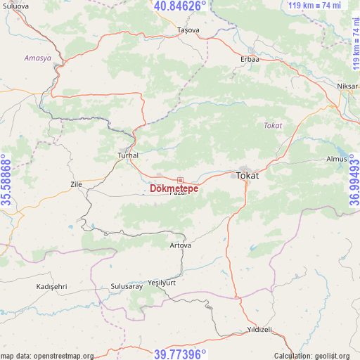
Dökmetepe GPS coordinates[2]
40° 18' 44.064" North, 36° 17' 30.48" East
| Map corner | latitude | longitude |
|---|---|---|
| Upper-left | 40.84626°, | 35.58868° |
| Center: | 40.31224°, | 36.2918° |
| Lower-right: | 39.77396°, | 36.99493° |
| Map W x H: | 119.2×119.2 km | = 74.1×74.1mi |
| max Lat: | 42.02683° ⇑25.5% North |
| Dökmetepe: | 40.31224° |
| min Lat: | ⇓74.5% South 35.9025° |
| min Long | Dökmetepe | max Long |
| 25.90902° | 36.2918° | 44.60099° |
| W 53.4%⇐ | ⇒46.6% E |
Elevation
Elevation of Dökmetepe is 561 m = 1841 ft, and this is 156.4 m = 513 ft below average elevation for this country.
| Max E: |
2682 m = 8799 ft | 56.7% |
| Avg. | 717.4 m = 2354 ft | |
| Dökmetepe | 561 m = 1841 ft | |
Min E: |
0 m = 0 ft | 43.3% |
See also: Turkey elevation on elevation.city.
Geographical zone
Dökmetepe is located in North temperate zone (between Tropic of Cancer and the Arctic Circle). Distance of this Northern Tropic circle is 1876.4 km =1165.9 mi to South.| Distance of | km | miles | from Dökmetepe |
|---|---|---|---|
| North Pole | 5524.8 | 3433 | to North |
| Arctic Circle | 2918.9 | 1813.7 | to North |
| Tropic Cancer | 1876.4 | 1165.9 | to South |
| Equator | 4482.3 | 2785.2 | to South |


Nearby cities:
15 places around Dökmetepe: (largest is in red/bold)
• Artova
21.9 km =13.6 mi,  178°
178°
• Boztepe
37 km =23 mi,  248°
248°
• Esençay
40.3 km =25 mi,  10°
10°
• Ezinepazarı
31.4 km =19.5 mi,  335°
335°
• Gökdere
42.9 km =26.7 mi,  65°
65°
• Kozlu
36.6 km =22.7 mi,  25°
25°
• Pazar
4 km =2.5 mi,  190°
190°
• Sulusaray
39.6 km =24.6 mi,  206°
206°
• Tekke
45.6 km =28.3 mi,  349°
349°
• Tokat
22.3 km =13.9 mi,  89°
89°
• Turhal
19.7 km =12.2 mi,  295°
295°
• Yeşilyurt
5.3 km =3.3 mi, 71°
• Yeşilyurt
34.5 km =21.4 mi, 190°
• Zile
34.4 km =21.4 mi,  268°
268°
• Çamlıbel
29.6 km =18.4 mi,  147°
147°
Sources, notices
• [Note1] Compared only with cities in Turkey existing in our database
• [Src1] Map data: © OpenStreetMap contributors (CC-BY-SA)
• [Src2] Other city data from geonames.org with taken over terms of usage.
• [Src3] Geographical zone / Annual Mean Temperature by Robert A. Rohde @ Wikipedia
