Yeşilyurt geodata
Yeşilyurt (Tokat) is a populated place; located in Turkey in Europe/Istanbul (GMT+3) time zone. With population of 6,860 people, there are 616 cities with bigger population in this country. Compared to other cities in Turkey, 74.9% of cities are located further ↓South; 53.8% of cities are located further ←West and 55.9% of cities have higher elevation than Yeşilyurt. Note1


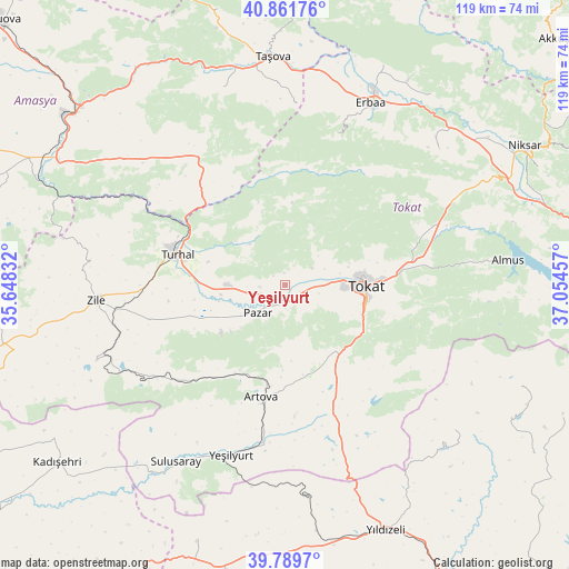
Yeşilyurt GPS coordinates[2]
40° 19' 40.296" North, 36° 21' 5.184" East
| Map corner | latitude | longitude |
|---|---|---|
| Upper-left | 40.86176°, | 35.64832° |
| Center: | 40.32786°, | 36.35144° |
| Lower-right: | 39.7897°, | 37.05457° |
| Map W x H: | 119.2×119.2 km | = 74.1×74.1mi |
| max Lat: | 42.02683° ⇑25.1% North |
| Yeşilyurt: | 40.32786° |
| min Lat: | ⇓74.9% South 35.9025° |
| min Long | Yeşilyurt | max Long |
| 25.90902° | 36.35144° | 44.60099° |
| W 53.8%⇐ | ⇒46.2% E |
Elevation
Elevation of Yeşilyurt is 574 m = 1883 ft, and this is 143.4 m = 470 ft below average elevation for this country.
| Max E: |
2682 m = 8799 ft | 55.9% |
| Avg. | 717.4 m = 2354 ft | |
| Yeşilyurt | 574 m = 1883 ft | |
Min E: |
0 m = 0 ft | 44.1% |
See also: Turkey elevation on elevation.city.
Geographical zone
Yeşilyurt is located in North temperate zone (between Tropic of Cancer and the Arctic Circle). Distance of this Northern Tropic circle is 1878.1 km =1167 mi to South.| Distance of | km | miles | from Yeşilyurt |
|---|---|---|---|
| North Pole | 5523 | 3431.8 | to North |
| Arctic Circle | 2917.1 | 1812.6 | to North |
| Tropic Cancer | 1878.1 | 1167 | to South |
| Equator | 4484 | 2786.2 | to South |


Nearby cities:
15 places around Yeşilyurt: (largest is in red/bold)
• Artova
24 km =14.9 mi,  190°
190°
• Boztepe
42.3 km =26.3 mi,  248°
248°
• Dökmetepe
5.3 km =3.3 mi, 251°
• Erbaa
42.1 km =26.2 mi,  25°
25°
• Esençay
37.9 km =23.5 mi,  3°
3°
• Ezinepazarı
32.3 km =20.1 mi,  326°
326°
• Gökdere
37.6 km =23.4 mi,  64°
64°
• Gökçeli
43 km =26.7 mi,  48°
48°
• Kozlu
33 km =20.5 mi,  18°
18°
• Pazar
8.1 km =5 mi,  225°
225°
• Tokat
17.3 km =10.7 mi,  95°
95°
• Turhal
23.8 km =14.8 mi,  286°
286°
• Yeşilyurt
37.4 km =23.2 mi,  197°
197°
• Zile
39.5 km =24.5 mi,  265°
265°
• Çamlıbel
28.9 km =18 mi,  158°
158°
Sources, notices
• [Note1] Compared only with cities in Turkey existing in our database
• [Src1] Map data: © OpenStreetMap contributors (CC-BY-SA)
• [Src2] Other city data from geonames.org with taken over terms of usage.
• [Src3] Geographical zone / Annual Mean Temperature by Robert A. Rohde @ Wikipedia
