İğdir geodata
İğdir (Tokat) is a seat of a third-order administrative division; located in Turkey in Europe/Istanbul (GMT+3) time zone. In our database, there are 1323 cities with bigger population. Compared to other cities in Turkey, 73.8% of cities are located further ↓South; 51.4% of cities are located further →East and 66.7% of cities have lower elevation than İğdir. Note1


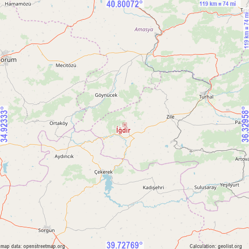
İğdir GPS coordinates[2]
40° 15' 58.788" North, 35° 37' 35.22" East
| Map corner | latitude | longitude |
|---|---|---|
| Upper-left | 40.80072°, | 34.92333° |
| Center: | 40.26633°, | 35.62645° |
| Lower-right: | 39.72769°, | 36.32958° |
| Map W x H: | 119.3×119.3 km | = 74.1×74.1mi |
| max Lat: | 42.02683° ⇑26.2% North |
| İğdir: | 40.26633° |
| min Lat: | ⇓73.8% South 35.9025° |
| min Long | İğdir | max Long |
| 25.90902° | 35.62645° | 44.60099° |
| W 48.6%⇐ | ⇒51.4% E |
Elevation
Elevation of İğdir is 982 m = 3222 ft, and this is 264.6 m = 868 ft above average elevation for this country.
| Max E: |
2682 m = 8799 ft | 33.3% |
| İğdir | 982 m 3222 ft | |
| Avg. | 717.4 m = 2354 ft | |
Min E: |
0 m = 0 ft | 66.7% |
See also: Turkey elevation on elevation.city.
Geographical zone
İğdir is located in North temperate zone (between Tropic of Cancer and the Arctic Circle). Distance of this Northern Tropic circle is 1871.3 km =1162.8 mi to South.| Distance of | km | miles | from İğdir |
|---|---|---|---|
| North Pole | 5529.9 | 3436.1 | to North |
| Arctic Circle | 2924 | 1816.9 | to North |
| Tropic Cancer | 1871.3 | 1162.8 | to South |
| Equator | 4477.2 | 2782 | to South |


Nearby cities:
15 places around İğdir: (largest is in red/bold)
• Amasya
46.4 km =28.8 mi,  22°
22°
• Aydıncık
32.7 km =20.3 mi,  241°
241°
• Boztepe
23.8 km =14.8 mi,  111°
111°
• Cemilbey
49.5 km =30.8 mi,  280°
280°
• Doğantepe
36.9 km =22.9 mi,  357°
357°
• Eymir
44.9 km =27.9 mi,  232°
232°
• Gediksaray
19.9 km =12.4 mi, 359°
• Göynücek
17.1 km =10.6 mi,  329°
329°
• Kadışehri
33.2 km =20.6 mi,  154°
154°
• Mecitözü
39.8 km =24.7 mi,  315°
315°
• Ortaköy
31.8 km =19.8 mi,  271°
271°
• Sulusaray
49.3 km =30.6 mi,  127°
127°
• Turhal
40.8 km =25.4 mi,  70°
70°
• Zile
22.4 km =13.9 mi,  79°
79°
• Çekerek
24.2 km =15 mi,  207°
207°
Sources, notices
• [Note1] Compared only with cities in Turkey existing in our database
• [Src1] Map data: © OpenStreetMap contributors (CC-BY-SA)
• [Src2] Other city data from geonames.org with taken over terms of usage.
• [Src3] Geographical zone / Annual Mean Temperature by Robert A. Rohde @ Wikipedia
