Kıbrıscık geodata
Kıbrıscık (Bolu) is a seat of a second-order administrative division; located in Turkey in Europe/Istanbul (GMT+3) time zone. With population of 3,114 people, there are 853 cities with bigger population in this country. Compared to other cities in Turkey, 76.2% of cities are located further ↓South; 67.2% of cities are located further →East and 76.3% of cities have lower elevation than Kıbrıscık. Note1


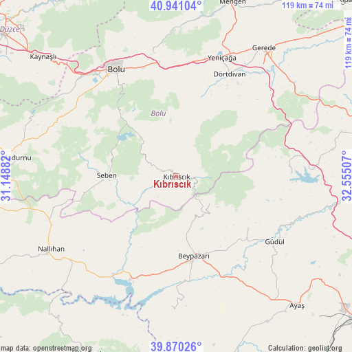
Kıbrıscık GPS coordinates[2]
40° 24' 28.008" North, 31° 51' 6.984" East
| Map corner | latitude | longitude |
|---|---|---|
| Upper-left | 40.94104°, | 31.14882° |
| Center: | 40.40778°, | 31.85194° |
| Lower-right: | 39.87026°, | 32.55507° |
| Map W x H: | 119.1×119.1 km | = 74×74mi |
| max Lat: | 42.02683° ⇑23.8% North |
| Kıbrıscık: | 40.40778° |
| min Lat: | ⇓76.2% South 35.9025° |
| min Long | Kıbrıscık | max Long |
| 25.90902° | 31.85194° | 44.60099° |
| W 32.8%⇐ | ⇒67.2% E |
Elevation
Elevation of Kıbrıscık is 1126 m = 3694 ft, and this is 408.6 m = 1341 ft above average elevation for this country.
| Max E: |
2682 m = 8799 ft | 23.7% |
| Kıbrıscık | 1126 m 3694 ft | |
| Avg. | 717.4 m = 2354 ft | |
Min E: |
0 m = 0 ft | 76.3% |
See also: Turkey elevation on elevation.city.
Geographical zone
Kıbrıscık is located in North temperate zone (between Tropic of Cancer and the Arctic Circle). Distance of this Northern Tropic circle is 1887 km =1172.5 mi to South.| Distance of | km | miles | from Kıbrıscık |
|---|---|---|---|
| North Pole | 5514.1 | 3426.3 | to North |
| Arctic Circle | 2908.3 | 1807.1 | to North |
| Tropic Cancer | 1887 | 1172.5 | to South |
| Equator | 4492.9 | 2791.8 | to South |


Nearby cities:
15 places around Kıbrıscık: (largest is in red/bold)
• Beypazarı
27.4 km =17 mi,  167°
167°
• Bolu
42 km =26.1 mi,  330°
330°
• Dörtdivan
39.1 km =24.3 mi,  27°
27°
• Gelegra
43.8 km =27.2 mi,  182°
182°
• Gerede
52.5 km =32.6 mi, 33°
• Güdül
39.9 km =24.8 mi,  123°
123°
• Karaşar
14.6 km =9.1 mi,  128°
128°
• Nallıhan
49.1 km =30.5 mi,  239°
239°
• Peçenek
38.7 km =24 mi,  88°
88°
• Seben
23.6 km =14.7 mi,  270°
270°
• Uruş
30 km =18.6 mi, 126°
• Yeniçağa
43.2 km =26.8 mi,  20°
20°
• Çamlıdere
53.5 km =33.2 mi,  80°
80°
• Çayırhan
37.6 km =23.4 mi,  203°
203°
• Çeltikçi
52 km =32.3 mi,  100°
100°
Sources, notices
• [Note1] Compared only with cities in Turkey existing in our database
• [Src1] Map data: © OpenStreetMap contributors (CC-BY-SA)
• [Src2] Other city data from geonames.org with taken over terms of usage.
• [Src3] Geographical zone / Annual Mean Temperature by Robert A. Rohde @ Wikipedia
