Uzunköprü geodata
Uzunköprü (Edirne) is a seat of a second-order administrative division; located in Turkey in Europe/Istanbul (GMT+3) time zone. With population of 36,470 people, there are 217 cities with bigger population in this country. Compared to other cities in Turkey, 95.3% of cities are located further ↓South; 98.4% of cities are located further →East and 91% of cities have higher elevation than Uzunköprü. Note1


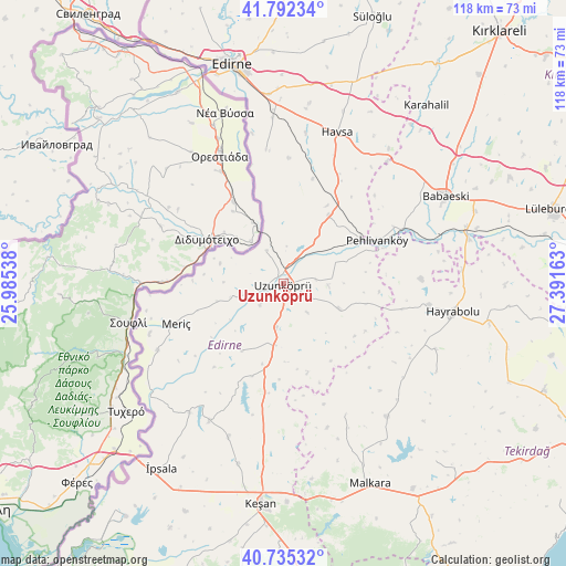
Uzunköprü GPS coordinates[2]
41° 15' 57.492" North, 26° 41' 18.6" East
| Map corner | latitude | longitude |
|---|---|---|
| Upper-left | 41.79234°, | 25.98538° |
| Center: | 41.26597°, | 26.6885° |
| Lower-right: | 40.73532°, | 27.39163° |
| Map W x H: | 117.5×117.5 km | = 73×73mi |
| max Lat: | 42.02683° ⇑4.7% North |
| Uzunköprü: | 41.26597° |
| min Lat: | ⇓95.3% South 35.9025° |
| min Long | Uzunköprü | max Long |
| 25.90902° | 26.6885° | 44.60099° |
| W 1.6%⇐ | ⇒98.4% E |
Elevation
Elevation of Uzunköprü is 34 m = 112 ft, and this is 683.4 m = 2242 ft below average elevation for this country.
| Max E: |
2682 m = 8799 ft | 91% |
| Avg. | 717.4 m = 2354 ft | |
| Uzunköprü | 34 m = 112 ft | |
Min E: |
0 m = 0 ft | 9% |
See also: Turkey elevation on elevation.city.
Geographical zone
Uzunköprü is located in North temperate zone (between Tropic of Cancer and the Arctic Circle). Distance of this Northern Tropic circle is 1982.4 km =1231.8 mi to South.| Distance of | km | miles | from Uzunköprü |
|---|---|---|---|
| North Pole | 5418.7 | 3367 | to North |
| Arctic Circle | 2812.8 | 1747.8 | to North |
| Tropic Cancer | 1982.4 | 1231.8 | to South |
| Equator | 4588.3 | 2851 | to South |


Nearby cities:
15 places around Uzunköprü: (largest is in red/bold)
• Babaeski
38.5 km =23.9 mi,  61°
61°
• Hamidiye
12.9 km =8 mi,  189°
189°
• Hasköy
43.7 km =27.2 mi,  18°
18°
• Havsa
33.4 km =20.8 mi, 19°
• Hayrabolu
35.5 km =22.1 mi,  99°
99°
• Karakasım
28.2 km =17.5 mi,  352°
352°
• Küplü
33.3 km =20.7 mi,  237°
237°
• Kırcasalih
16.4 km =10.2 mi,  32°
32°
• Malkara
45.4 km =28.2 mi,  156°
156°
• Meriç
23.8 km =14.8 mi,  249°
249°
• Pehlivanköy
21.8 km =13.5 mi,  65°
65°
• Susuzmüsellim
36.8 km =22.9 mi,  120°
120°
• Çöpköy
12.3 km =7.6 mi,  114°
114°
• İbriktepe
32.4 km =20.1 mi,  208°
208°
• Şahin
30.1 km =18.7 mi,  154°
154°
Sources, notices
• [Note1] Compared only with cities in Turkey existing in our database
• [Src1] Map data: © OpenStreetMap contributors (CC-BY-SA)
• [Src2] Other city data from geonames.org with taken over terms of usage.
• [Src3] Geographical zone / Annual Mean Temperature by Robert A. Rohde @ Wikipedia
