Hamidiye geodata
Hamidiye (Edirne) is a seat of a third-order administrative division; located in Turkey in Europe/Istanbul (GMT+3) time zone. In our database, there are 1323 cities with bigger population. Compared to other cities in Turkey, 93.1% of cities are located further ↓South; 98.6% of cities are located further →East and 81.6% of cities have higher elevation than Hamidiye. Note1


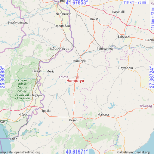
Hamidiye GPS coordinates[2]
41° 9' 4.608" North, 26° 39' 50.796" East
| Map corner | latitude | longitude |
|---|---|---|
| Upper-left | 41.67858°, | 25.96099° |
| Center: | 41.15128°, | 26.66411° |
| Lower-right: | 40.61971°, | 27.36724° |
| Map W x H: | 117.7×117.7 km | = 73.1×73.1mi |
| max Lat: | 42.02683° ⇑6.9% North |
| Hamidiye: | 41.15128° |
| min Lat: | ⇓93.1% South 35.9025° |
| min Long | Hamidiye | max Long |
| 25.90902° | 26.66411° | 44.60099° |
| W 1.4%⇐ | ⇒98.6% E |
Elevation
Elevation of Hamidiye is 99 m = 325 ft, and this is 618.4 m = 2029 ft below average elevation for this country.
| Max E: |
2682 m = 8799 ft | 81.6% |
| Avg. | 717.4 m = 2354 ft | |
| Hamidiye | 99 m = 325 ft | |
Min E: |
0 m = 0 ft | 18.4% |
See also: Turkey elevation on elevation.city.
Geographical zone
Hamidiye is located in North temperate zone (between Tropic of Cancer and the Arctic Circle). Distance of this Northern Tropic circle is 1969.7 km =1223.9 mi to South.| Distance of | km | miles | from Hamidiye |
|---|---|---|---|
| North Pole | 5431.5 | 3375 | to North |
| Arctic Circle | 2825.6 | 1755.7 | to North |
| Tropic Cancer | 1969.7 | 1223.9 | to South |
| Equator | 4575.6 | 2843.1 | to South |


Nearby cities:
15 places around Hamidiye: (largest is in red/bold)
• Hayrabolu
37.7 km =23.4 mi,  79°
79°
• Karakasım
40.7 km =25.3 mi,  357°
357°
• Keşan
33 km =20.5 mi,  184°
184°
• Küplü
26.6 km =16.5 mi,  259°
259°
• Kırcasalih
28.7 km =17.8 mi,  22°
22°
• Malkara
35.2 km =21.9 mi,  145°
145°
• Meriç
20.8 km =12.9 mi,  282°
282°
• Pehlivanköy
30.9 km =19.2 mi,  44°
44°
• Susuzmüsellim
34.3 km =21.3 mi,  99°
99°
• Uzunköprü
12.9 km =8 mi,  9°
9°
• Yürük
41.4 km =25.7 mi,  125°
125°
• Çöpköy
15.3 km =9.5 mi,  60°
60°
• İbriktepe
20.7 km =12.9 mi,  220°
220°
• İpsala
34.8 km =21.6 mi, 222°
• Şahin
20.8 km =12.9 mi, 133°
Sources, notices
• [Note1] Compared only with cities in Turkey existing in our database
• [Src1] Map data: © OpenStreetMap contributors (CC-BY-SA)
• [Src2] Other city data from geonames.org with taken over terms of usage.
• [Src3] Geographical zone / Annual Mean Temperature by Robert A. Rohde @ Wikipedia
