Çöpköy geodata
Çöpköy (Edirne) is a seat of a third-order administrative division; located in Turkey in Europe/Istanbul (GMT+3) time zone. In our database, there are 1323 cities with bigger population. Compared to other cities in Turkey, 94.5% of cities are located further ↓South; 97.9% of cities are located further →East and 84.1% of cities have higher elevation than Çöpköy. Note1


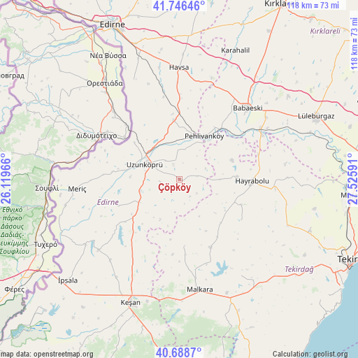
Çöpköy GPS coordinates[2]
41° 13' 10.992" North, 26° 49' 22.008" East
| Map corner | latitude | longitude |
|---|---|---|
| Upper-left | 41.74646°, | 26.11966° |
| Center: | 41.21972°, | 26.82278° |
| Lower-right: | 40.6887°, | 27.52591° |
| Map W x H: | 117.6×117.6 km | = 73.1×73.1mi |
| max Lat: | 42.02683° ⇑5.5% North |
| Çöpköy: | 41.21972° |
| min Lat: | ⇓94.5% South 35.9025° |
| min Long | Çöpköy | max Long |
| 25.90902° | 26.82278° | 44.60099° |
| W 2.1%⇐ | ⇒97.9% E |
Elevation
Elevation of Çöpköy is 79 m = 259 ft, and this is 638.4 m = 2094 ft below average elevation for this country.
| Max E: |
2682 m = 8799 ft | 84.1% |
| Avg. | 717.4 m = 2354 ft | |
| Çöpköy | 79 m = 259 ft | |
Min E: |
0 m = 0 ft | 15.9% |
See also: Turkey elevation on elevation.city.
Geographical zone
Çöpköy is located in North temperate zone (between Tropic of Cancer and the Arctic Circle). Distance of this Northern Tropic circle is 1977.3 km =1228.6 mi to South.| Distance of | km | miles | from Çöpköy |
|---|---|---|---|
| North Pole | 5423.9 | 3370.3 | to North |
| Arctic Circle | 2818 | 1751 | to North |
| Tropic Cancer | 1977.3 | 1228.6 | to South |
| Equator | 4583.2 | 2847.9 | to South |


Nearby cities:
15 places around Çöpköy: (largest is in red/bold)
• Babaeski
32.7 km =20.3 mi,  43°
43°
• Dambaslar
35.6 km =22.1 mi,  89°
89°
• Hamidiye
15.3 km =9.5 mi,  240°
240°
• Havsa
36.6 km =22.7 mi,  359°
359°
• Hayrabolu
23.8 km =14.8 mi, 91°
• Karakasım
36.3 km =22.6 mi,  335°
335°
• Kırcasalih
19.1 km =11.9 mi,  353°
353°
• Malkara
37.2 km =23.1 mi,  169°
169°
• Meriç
33.8 km =21 mi,  264°
264°
• Pehlivanköy
16.6 km =10.3 mi,  30°
30°
• Susuzmüsellim
24.5 km =15.2 mi,  123°
123°
• Uzunköprü
12.3 km =7.6 mi,  294°
294°
• Yürük
37.6 km =23.4 mi,  147°
147°
• İbriktepe
35.5 km =22.1 mi,  228°
228°
• Şahin
22.1 km =13.7 mi,  175°
175°
Sources, notices
• [Note1] Compared only with cities in Turkey existing in our database
• [Src1] Map data: © OpenStreetMap contributors (CC-BY-SA)
• [Src2] Other city data from geonames.org with taken over terms of usage.
• [Src3] Geographical zone / Annual Mean Temperature by Robert A. Rohde @ Wikipedia
