Topçam geodata
Topçam (Ordu) is a seat of a third-order administrative division; located in Turkey in Europe/Istanbul (GMT+3) time zone. In our database, there are 1323 cities with bigger population. Compared to other cities in Turkey, 79.3% of cities are located further ↓South; 60.3% of cities are located further ←West and 53.6% of cities have lower elevation than Topçam. Note1


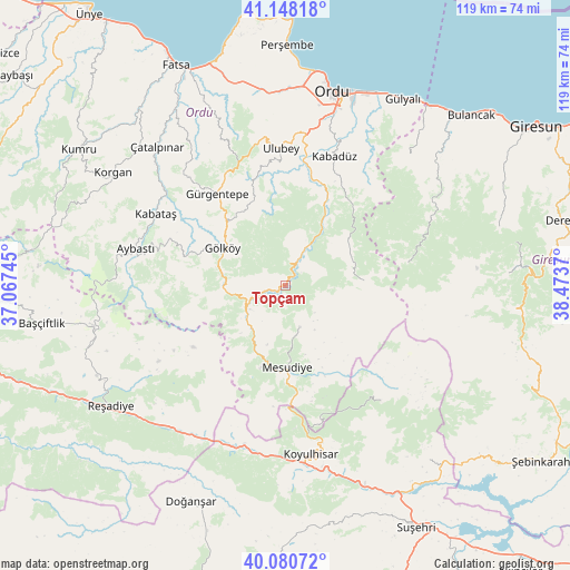
Topçam GPS coordinates[2]
40° 36' 59.688" North, 37° 46' 14.052" East
| Map corner | latitude | longitude |
|---|---|---|
| Upper-left | 41.14818°, | 37.06745° |
| Center: | 40.61658°, | 37.77057° |
| Lower-right: | 40.08072°, | 38.4737° |
| Map W x H: | 118.7×118.7 km | = 73.8×73.8mi |
| max Lat: | 42.02683° ⇑20.7% North |
| Topçam: | 40.61658° |
| min Lat: | ⇓79.3% South 35.9025° |
| min Long | Topçam | max Long |
| 25.90902° | 37.77057° | 44.60099° |
| W 60.3%⇐ | ⇒39.7% E |
Elevation
Elevation of Topçam is 768 m = 2520 ft, and this is 50.6 m = 166 ft above average elevation for this country.
| Max E: |
2682 m = 8799 ft | 46.4% |
| Topçam | 768 m 2520 ft | |
| Avg. | 717.4 m = 2354 ft | |
Min E: |
0 m = 0 ft | 53.6% |
See also: Turkey elevation on elevation.city.
Geographical zone
Topçam is located in North temperate zone (between Tropic of Cancer and the Arctic Circle). Distance of this Northern Tropic circle is 1910.2 km =1186.9 mi to South.| Distance of | km | miles | from Topçam |
|---|---|---|---|
| North Pole | 5490.9 | 3411.9 | to North |
| Arctic Circle | 2885 | 1792.7 | to North |
| Tropic Cancer | 1910.2 | 1186.9 | to South |
| Equator | 4516.1 | 2806.2 | to South |


Nearby cities:
15 places around Topçam: (largest is in red/bold)
• Aybastı
32.3 km =20.1 mi,  283°
283°
• Gölköy
15.2 km =9.4 mi,  300°
300°
• Gürgentepe
24.2 km =15 mi,  320°
320°
• Kabadüz
28.8 km =17.9 mi,  19°
19°
• Kabataş
30.8 km =19.1 mi, 298°
• Kovanlık
32.6 km =20.3 mi,  61°
61°
• Koyulhisar
35.3 km =21.9 mi,  172°
172°
• Mesudiye
18 km =11.2 mi,  179°
179°
• Ordu
41.4 km =25.7 mi,  14°
14°
• Ortakent
32 km =19.9 mi,  140°
140°
• Ulubey
28.1 km =17.5 mi,  357°
357°
• Uzunisa
33.8 km =21 mi, 11°
• Yeşilce
9.2 km =5.7 mi, 166°
• Çamaş
37.7 km =23.4 mi,  327°
327°
• Çatalpınar
39.6 km =24.6 mi, 317°
Sources, notices
• [Note1] Compared only with cities in Turkey existing in our database
• [Src1] Map data: © OpenStreetMap contributors (CC-BY-SA)
• [Src2] Other city data from geonames.org with taken over terms of usage.
• [Src3] Geographical zone / Annual Mean Temperature by Robert A. Rohde @ Wikipedia
