Kovanlık geodata
Kovanlık (Giresun) is a seat of a third-order administrative division; located in Turkey in Europe/Istanbul (GMT+3) time zone. In our database, there are 1323 cities with bigger population. Compared to other cities in Turkey, 82.4% of cities are located further ↓South; 62.3% of cities are located further ←West and 65.6% of cities have lower elevation than Kovanlık. Note1


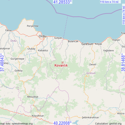
Kovanlık GPS coordinates[2]
40° 45' 17.424" North, 38° 6' 41.58" East
| Map corner | latitude | longitude |
|---|---|---|
| Upper-left | 41.28533°, | 37.40843° |
| Center: | 40.75484°, | 38.11155° |
| Lower-right: | 40.22008°, | 38.81468° |
| Map W x H: | 118.4×118.4 km | = 73.6×73.6mi |
| max Lat: | 42.02683° ⇑17.6% North |
| Kovanlık: | 40.75484° |
| min Lat: | ⇓82.4% South 35.9025° |
| min Long | Kovanlık | max Long |
| 25.90902° | 38.11155° | 44.60099° |
| W 62.3%⇐ | ⇒37.7% E |
Elevation
Elevation of Kovanlık is 969 m = 3179 ft, and this is 251.6 m = 825 ft above average elevation for this country.
| Max E: |
2682 m = 8799 ft | 34.4% |
| Kovanlık | 969 m 3179 ft | |
| Avg. | 717.4 m = 2354 ft | |
Min E: |
0 m = 0 ft | 65.6% |
See also: Turkey elevation on elevation.city.
Geographical zone
Kovanlık is located in North temperate zone (between Tropic of Cancer and the Arctic Circle). Distance of this Northern Tropic circle is 1925.6 km =1196.5 mi to South.| Distance of | km | miles | from Kovanlık |
|---|---|---|---|
| North Pole | 5475.5 | 3402.3 | to North |
| Arctic Circle | 2869.7 | 1783.1 | to North |
| Tropic Cancer | 1925.6 | 1196.5 | to South |
| Equator | 4531.5 | 2815.7 | to South |


Nearby cities:
15 places around Kovanlık: (largest is in red/bold)
• Altınordu
32.4 km =20.1 mi,  321°
321°
• Bulancak
22.7 km =14.1 mi,  26°
26°
• Dereli
28 km =17.4 mi,  93°
93°
• Giresun
29.4 km =18.3 mi,  52°
52°
• Gülyalı
23.6 km =14.7 mi,  347°
347°
• Kabadüz
22.4 km =13.9 mi,  301°
301°
• Keşap
37.1 km =23.1 mi,  62°
62°
• Ordu
31 km =19.3 mi, 323°
• Piraziz
18.7 km =11.6 mi,  3°
3°
• Piraziz
22 km =13.7 mi,  359°
359°
• Topçam
32.6 km =20.3 mi,  241°
241°
• Ulubey
32.6 km =20.3 mi,  292°
292°
• Uzunisa
28.4 km =17.6 mi,  308°
308°
• Yavuzkemal
20.2 km =12.6 mi,  109°
109°
• Yeşilce
36.1 km =22.4 mi,  227°
227°
Sources, notices
• [Note1] Compared only with cities in Turkey existing in our database
• [Src1] Map data: © OpenStreetMap contributors (CC-BY-SA)
• [Src2] Other city data from geonames.org with taken over terms of usage.
• [Src3] Geographical zone / Annual Mean Temperature by Robert A. Rohde @ Wikipedia
