Koyulhisar geodata
Koyulhisar (Sivas) is a seat of a second-order administrative division; located in Turkey in Europe/Istanbul (GMT+3) time zone. With population of 5,495 people, there are 686 cities with bigger population in this country. Compared to other cities in Turkey, 74.4% of cities are located further ↓South; 60.6% of cities are located further ←West and 59.4% of cities have lower elevation than Koyulhisar. Note1


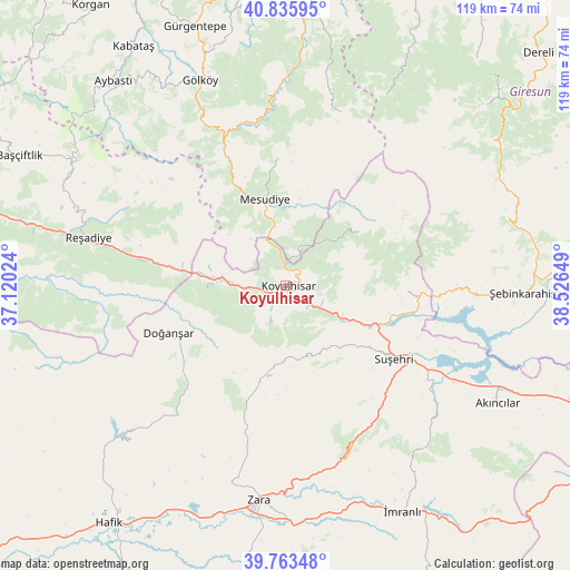
Koyulhisar GPS coordinates[2]
40° 18' 6.624" North, 37° 49' 24.096" East
| Map corner | latitude | longitude |
|---|---|---|
| Upper-left | 40.83595°, | 37.12024° |
| Center: | 40.30184°, | 37.82336° |
| Lower-right: | 39.76348°, | 38.52649° |
| Map W x H: | 119.2×119.2 km | = 74.1×74.1mi |
| max Lat: | 42.02683° ⇑25.6% North |
| Koyulhisar: | 40.30184° |
| min Lat: | ⇓74.4% South 35.9025° |
| min Long | Koyulhisar | max Long |
| 25.90902° | 37.82336° | 44.60099° |
| W 60.6%⇐ | ⇒39.4% E |
Elevation
Elevation of Koyulhisar is 872 m = 2861 ft, and this is 154.6 m = 507 ft above average elevation for this country.
| Max E: |
2682 m = 8799 ft | 40.6% |
| Koyulhisar | 872 m 2861 ft | |
| Avg. | 717.4 m = 2354 ft | |
Min E: |
0 m = 0 ft | 59.4% |
See also: Turkey elevation on elevation.city.
Geographical zone
Koyulhisar is located in North temperate zone (between Tropic of Cancer and the Arctic Circle). Distance of this Northern Tropic circle is 1875.2 km =1165.2 mi to South.| Distance of | km | miles | from Koyulhisar |
|---|---|---|---|
| North Pole | 5525.9 | 3433.6 | to North |
| Arctic Circle | 2920 | 1814.4 | to North |
| Tropic Cancer | 1875.2 | 1165.2 | to South |
| Equator | 4481.1 | 2784.4 | to South |


Nearby cities:
15 places around Koyulhisar: (largest is in red/bold)
• Aksu
29.6 km =18.4 mi,  142°
142°
• Akıncılar
51 km =31.7 mi,  120°
120°
• Bereketli
51 km =31.7 mi,  297°
297°
• Doğanşar
26.9 km =16.7 mi,  247°
247°
• Gökçekent
25 km =15.5 mi,  93°
93°
• Gölköy
46.3 km =28.8 mi,  337°
337°
• Mesudiye
17.5 km =10.9 mi,  346°
346°
• Ortakent
18.8 km =11.7 mi,  57°
57°
• Reşadiye
42.4 km =26.3 mi,  283°
283°
• Suşehri
27.2 km =16.9 mi,  125°
125°
• Topçam
35.3 km =21.9 mi, 352°
• Yeşilce
26.1 km =16.2 mi, 354°
• Zara
45.3 km =28.1 mi,  187°
187°
• Şebin Karahisar
50.9 km =31.6 mi, 91°
• Şerefiye
21.9 km =13.6 mi,  195°
195°
Sources, notices
• [Note1] Compared only with cities in Turkey existing in our database
• [Src1] Map data: © OpenStreetMap contributors (CC-BY-SA)
• [Src2] Other city data from geonames.org with taken over terms of usage.
• [Src3] Geographical zone / Annual Mean Temperature by Robert A. Rohde @ Wikipedia
