Tatkavaklı geodata
Tatkavaklı (Bursa) is a populated place; located in Turkey in Europe/Istanbul (GMT+3) time zone. With population of 3,415 people, there are 828 cities with bigger population in this country. Compared to other cities in Turkey, 69.6% of cities are located further ↓South; 87.8% of cities are located further →East and 90.7% of cities have higher elevation than Tatkavaklı. Note1


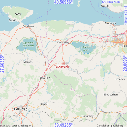
Tatkavaklı GPS coordinates[2]
40° 1' 59.988" North, 28° 22' 0.012" East
| Map corner | latitude | longitude |
|---|---|---|
| Upper-left | 40.56956°, | 27.66355° |
| Center: | 40.03333°, | 28.36667° |
| Lower-right: | 39.49285°, | 29.0698° |
| Map W x H: | 119.7×119.7 km | = 74.4×74.4mi |
| max Lat: | 42.02683° ⇑30.4% North |
| Tatkavaklı: | 40.03333° |
| min Lat: | ⇓69.6% South 35.9025° |
| min Long | Tatkavaklı | max Long |
| 25.90902° | 28.36667° | 44.60099° |
| W 12.2%⇐ | ⇒87.8% E |
Elevation
Elevation of Tatkavaklı is 36 m = 118 ft, and this is 681.4 m = 2236 ft below average elevation for this country.
| Max E: |
2682 m = 8799 ft | 90.7% |
| Avg. | 717.4 m = 2354 ft | |
| Tatkavaklı | 36 m = 118 ft | |
Min E: |
0 m = 0 ft | 9.3% |
See also: Turkey elevation on elevation.city.
Geographical zone
Tatkavaklı is located in North temperate zone (between Tropic of Cancer and the Arctic Circle). Distance of this Northern Tropic circle is 1845.4 km =1146.7 mi to South.| Distance of | km | miles | from Tatkavaklı |
|---|---|---|---|
| North Pole | 5555.8 | 3452.2 | to North |
| Arctic Circle | 2949.9 | 1833 | to North |
| Tropic Cancer | 1845.4 | 1146.7 | to South |
| Equator | 4451.3 | 2765.9 | to South |


Nearby cities:
15 places around Tatkavaklı: (largest is in red/bold)
• Aksakal
25.5 km =15.8 mi,  299°
299°
• Devecikonağı
21.2 km =13.2 mi,  128°
128°
• Durak
37.2 km =23.1 mi,  192°
192°
• Göbel
18.9 km =11.7 mi,  265°
265°
• Karacabey
20 km =12.4 mi,  358°
358°
• Kavacık
41.3 km =25.7 mi,  164°
164°
• Kepsut
42.4 km =26.3 mi,  205°
205°
• Mahmudiye
41.5 km =25.8 mi,  35°
35°
• Manyas
33.8 km =21 mi, 272°
• Mustafakemalpaşa
3.6 km =2.2 mi,  81°
81°
• Soldere
17.8 km =11.1 mi, 80°
• Susurluk
22.2 km =13.8 mi,  233°
233°
• Yeniköy
42 km =26.1 mi, 227°
• Çaltılıbük
21.6 km =13.4 mi,  113°
113°
• Ömerköy
34.1 km =21.2 mi, 228°
Sources, notices
• [Note1] Compared only with cities in Turkey existing in our database
• [Src1] Map data: © OpenStreetMap contributors (CC-BY-SA)
• [Src2] Other city data from geonames.org with taken over terms of usage.
• [Src3] Geographical zone / Annual Mean Temperature by Robert A. Rohde @ Wikipedia
