Aksakal geodata
Aksakal (Balıkesir) is a seat of a third-order administrative division; located in Turkey in Europe/Istanbul (GMT+3) time zone. In our database, there are 1323 cities with bigger population. Compared to other cities in Turkey, 71.6% of cities are located further ↓South; 89.4% of cities are located further →East and 87.5% of cities have higher elevation than Aksakal. Note1


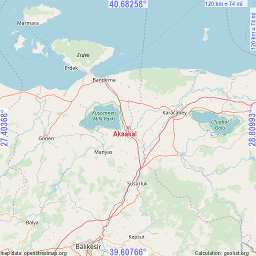
Aksakal GPS coordinates[2]
40° 8' 50.1" North, 28° 6' 24.48" East
| Map corner | latitude | longitude |
|---|---|---|
| Upper-left | 40.68258°, | 27.40368° |
| Center: | 40.14725°, | 28.1068° |
| Lower-right: | 39.60766°, | 28.80993° |
| Map W x H: | 119.5×119.5 km | = 74.3×74.3mi |
| max Lat: | 42.02683° ⇑28.4% North |
| Aksakal: | 40.14725° |
| min Lat: | ⇓71.6% South 35.9025° |
| min Long | Aksakal | max Long |
| 25.90902° | 28.1068° | 44.60099° |
| W 10.6%⇐ | ⇒89.4% E |
Elevation
Elevation of Aksakal is 54 m = 177 ft, and this is 663.4 m = 2177 ft below average elevation for this country.
| Max E: |
2682 m = 8799 ft | 87.5% |
| Avg. | 717.4 m = 2354 ft | |
| Aksakal | 54 m = 177 ft | |
Min E: |
0 m = 0 ft | 12.5% |
See also: Turkey elevation on elevation.city.
Geographical zone
Aksakal is located in North temperate zone (between Tropic of Cancer and the Arctic Circle). Distance of this Northern Tropic circle is 1858 km =1154.5 mi to South.| Distance of | km | miles | from Aksakal |
|---|---|---|---|
| North Pole | 5543.1 | 3444.3 | to North |
| Arctic Circle | 2937.2 | 1825.1 | to North |
| Tropic Cancer | 1858 | 1154.5 | to South |
| Equator | 4464 | 2773.8 | to South |


Nearby cities:
15 places around Aksakal: (largest is in red/bold)
• Bandırma
25.3 km =15.7 mi,  334°
334°
• Buğdaylı
29.7 km =18.5 mi,  285°
285°
• Darıca
25 km =15.5 mi,  235°
235°
• Edincik
30.1 km =18.7 mi,  316°
316°
• Erdek
38.6 km =24 mi, 316°
• Göbel
14.6 km =9.1 mi,  166°
166°
• Gönen
38.8 km =24.1 mi,  263°
263°
• Karacabey
22.8 km =14.2 mi,  71°
71°
• Manyas
16.2 km =10.1 mi,  226°
226°
• Mustafakemalpaşa
28.4 km =17.6 mi,  115°
115°
• Susurluk
26.3 km =16.3 mi, 170°
• Tatkavaklı
25.5 km =15.8 mi, 119°
• Tütüncü
34.1 km =21.2 mi,  254°
254°
• Ömerköy
35.4 km =22 mi,  185°
185°
• Şevketiye
22.9 km =14.2 mi, 254°
Sources, notices
• [Note1] Compared only with cities in Turkey existing in our database
• [Src1] Map data: © OpenStreetMap contributors (CC-BY-SA)
• [Src2] Other city data from geonames.org with taken over terms of usage.
• [Src3] Geographical zone / Annual Mean Temperature by Robert A. Rohde @ Wikipedia
