Çaltılıbük geodata
Çaltılıbük (Bursa) is a seat of a third-order administrative division; located in Turkey in Europe/Istanbul (GMT+3) time zone. In our database, there are 1323 cities with bigger population. Compared to other cities in Turkey, 68.5% of cities are located further ↓South; 86.5% of cities are located further →East and 83.9% of cities have higher elevation than Çaltılıbük. Note1


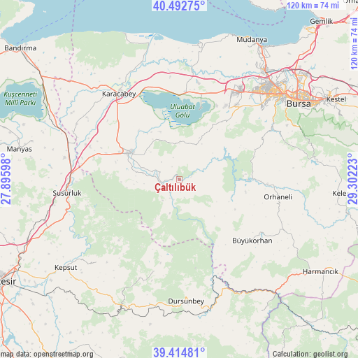
Çaltılıbük GPS coordinates[2]
39° 57' 21.24" North, 28° 35' 56.76" East
| Map corner | latitude | longitude |
|---|---|---|
| Upper-left | 40.49275°, | 27.89598° |
| Center: | 39.9559°, | 28.5991° |
| Lower-right: | 39.41481°, | 29.30223° |
| Map W x H: | 119.9×119.9 km | = 74.5×74.5mi |
| max Lat: | 42.02683° ⇑31.5% North |
| Çaltılıbük: | 39.9559° |
| min Lat: | ⇓68.5% South 35.9025° |
| min Long | Çaltılıbük | max Long |
| 25.90902° | 28.5991° | 44.60099° |
| W 13.5%⇐ | ⇒86.5% E |
Elevation
Elevation of Çaltılıbük is 81 m = 266 ft, and this is 636.4 m = 2088 ft below average elevation for this country.
| Max E: |
2682 m = 8799 ft | 83.9% |
| Avg. | 717.4 m = 2354 ft | |
| Çaltılıbük | 81 m = 266 ft | |
Min E: |
0 m = 0 ft | 16.1% |
See also: Turkey elevation on elevation.city.
Geographical zone
Çaltılıbük is located in North temperate zone (between Tropic of Cancer and the Arctic Circle). Distance of this Northern Tropic circle is 1836.8 km =1141.3 mi to South.| Distance of | km | miles | from Çaltılıbük |
|---|---|---|---|
| North Pole | 5564.4 | 3457.6 | to North |
| Arctic Circle | 2958.5 | 1838.3 | to North |
| Tropic Cancer | 1836.8 | 1141.3 | to South |
| Equator | 4442.7 | 2760.6 | to South |


Nearby cities:
15 places around Çaltılıbük: (largest is in red/bold)
• Büyükorhan
32 km =19.9 mi,  130°
130°
• Devecikonağı
5.6 km =3.5 mi,  214°
214°
• Göbel
39.3 km =24.4 mi,  280°
280°
• Görükle
36.8 km =22.9 mi,  33°
33°
• Karacabey
35 km =21.7 mi,  324°
324°
• Karıncalı
22.2 km =13.8 mi,  85°
85°
• Kavacık
32.4 km =20.1 mi,  195°
195°
• Mustafakemalpaşa
18.6 km =11.6 mi,  299°
299°
• Nilüfer
39.4 km =24.5 mi,  43°
43°
• Orhaneli
33.9 km =21.1 mi,  99°
99°
• Soldere
11.9 km =7.4 mi,  348°
348°
• Susurluk
37.9 km =23.5 mi,  262°
262°
• Tatkavaklı
21.6 km =13.4 mi,  293°
293°
• Yenice
34.1 km =21.2 mi, 129°
• Çalı
36.2 km =22.5 mi,  49°
49°
Sources, notices
• [Note1] Compared only with cities in Turkey existing in our database
• [Src1] Map data: © OpenStreetMap contributors (CC-BY-SA)
• [Src2] Other city data from geonames.org with taken over terms of usage.
• [Src3] Geographical zone / Annual Mean Temperature by Robert A. Rohde @ Wikipedia
