Karacabey geodata
Karacabey (Bursa) is a seat of a second-order administrative division; located in Turkey in Europe/Istanbul (GMT+3) time zone. With population of 44,256 people, there are 195 cities with bigger population in this country. Compared to other cities in Turkey, 72.9% of cities are located further ↓South; 88% of cities are located further →East and 92.6% of cities have higher elevation than Karacabey. Note1


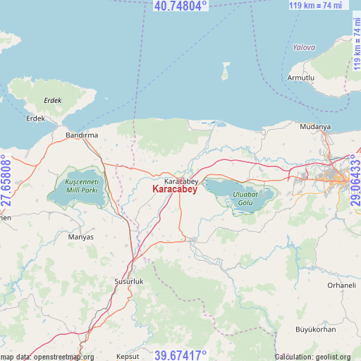
Karacabey GPS coordinates[2]
40° 12' 47.628" North, 28° 21' 40.32" East
| Map corner | latitude | longitude |
|---|---|---|
| Upper-left | 40.74804°, | 27.65808° |
| Center: | 40.21323°, | 28.3612° |
| Lower-right: | 39.67417°, | 29.06433° |
| Map W x H: | 119.4×119.4 km | = 74.2×74.2mi |
| max Lat: | 42.02683° ⇑27.1% North |
| Karacabey: | 40.21323° |
| min Lat: | ⇓72.9% South 35.9025° |
| min Long | Karacabey | max Long |
| 25.90902° | 28.3612° | 44.60099° |
| W 12%⇐ | ⇒88% E |
Elevation
Elevation of Karacabey is 26 m = 85 ft, and this is 691.4 m = 2268 ft below average elevation for this country.
| Max E: |
2682 m = 8799 ft | 92.6% |
| Avg. | 717.4 m = 2354 ft | |
| Karacabey | 26 m = 85 ft | |
Min E: |
0 m = 0 ft | 7.4% |
See also: Karacabey elevation on elevation.city.
Geographical zone
Karacabey is located in North temperate zone (between Tropic of Cancer and the Arctic Circle). Distance of this Northern Tropic circle is 1865.4 km =1159.1 mi to South.| Distance of | km | miles | from Karacabey |
|---|---|---|---|
| North Pole | 5535.8 | 3439.8 | to North |
| Arctic Circle | 2929.9 | 1820.6 | to North |
| Tropic Cancer | 1865.4 | 1159.1 | to South |
| Equator | 4471.3 | 2778.3 | to South |


Nearby cities:
15 places around Karacabey: (largest is in red/bold)
• Aksakal
22.8 km =14.2 mi,  251°
251°
• Bandırma
36.1 km =22.4 mi,  295°
295°
• Devecikonağı
37.3 km =23.2 mi,  152°
152°
• Edincik
44.8 km =27.8 mi,  288°
288°
• Göbel
28.3 km =17.6 mi,  220°
220°
• Görükle
40.7 km =25.3 mi,  87°
87°
• Mahmudiye
28.1 km =17.5 mi,  60°
60°
• Manyas
38.1 km =23.7 mi,  240°
240°
• Mustafakemalpaşa
19.9 km =12.4 mi,  168°
168°
• Soldere
24.7 km =15.3 mi,  133°
133°
• Susurluk
37.5 km =23.3 mi,  207°
207°
• Tatkavaklı
20 km =12.4 mi,  178°
178°
• Zeytinbağı
41.9 km =26 mi, 61°
• Çaltılıbük
35 km =21.7 mi,  144°
144°
• Şevketiye
45.7 km =28.4 mi, 253°
Sources, notices
• [Note1] Compared only with cities in Turkey existing in our database
• [Src1] Map data: © OpenStreetMap contributors (CC-BY-SA)
• [Src2] Other city data from geonames.org with taken over terms of usage.
• [Src3] Geographical zone / Annual Mean Temperature by Robert A. Rohde @ Wikipedia
