Devecikonağı geodata
Devecikonağı (Bursa) is a seat of a third-order administrative division; located in Turkey in Europe/Istanbul (GMT+3) time zone. In our database, there are 1323 cities with bigger population. Compared to other cities in Turkey, 67.7% of cities are located further ↓South; 86.8% of cities are located further →East and 85.6% of cities have higher elevation than Devecikonağı. Note1


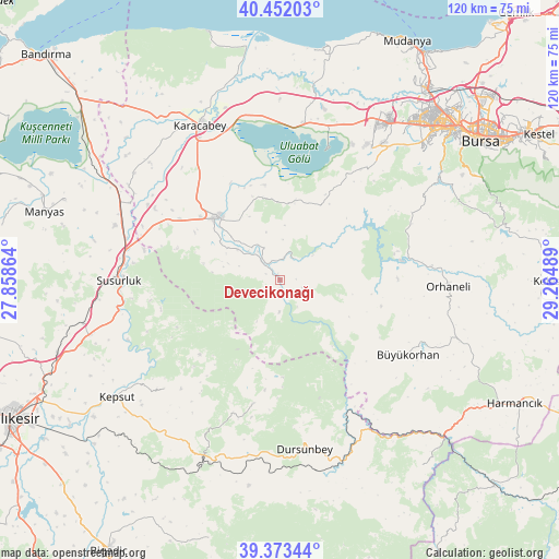
Devecikonağı GPS coordinates[2]
39° 54' 53.496" North, 28° 33' 42.336" East
| Map corner | latitude | longitude |
|---|---|---|
| Upper-left | 40.45203°, | 27.85864° |
| Center: | 39.91486°, | 28.56176° |
| Lower-right: | 39.37344°, | 29.26489° |
| Map W x H: | 119.9×119.9 km | = 74.5×74.5mi |
| max Lat: | 42.02683° ⇑32.3% North |
| Devecikonağı: | 39.91486° |
| min Lat: | ⇓67.7% South 35.9025° |
| min Long | Devecikonağı | max Long |
| 25.90902° | 28.56176° | 44.60099° |
| W 13.2%⇐ | ⇒86.8% E |
Elevation
Elevation of Devecikonağı is 67 m = 220 ft, and this is 650.4 m = 2134 ft below average elevation for this country.
| Max E: |
2682 m = 8799 ft | 85.6% |
| Avg. | 717.4 m = 2354 ft | |
| Devecikonağı | 67 m = 220 ft | |
Min E: |
0 m = 0 ft | 14.4% |
See also: Turkey elevation on elevation.city.
Geographical zone
Devecikonağı is located in North temperate zone (between Tropic of Cancer and the Arctic Circle). Distance of this Northern Tropic circle is 1832.2 km =1138.5 mi to South.| Distance of | km | miles | from Devecikonağı |
|---|---|---|---|
| North Pole | 5568.9 | 3460.4 | to North |
| Arctic Circle | 2963.1 | 1841.2 | to North |
| Tropic Cancer | 1832.2 | 1138.5 | to South |
| Equator | 4438.1 | 2757.7 | to South |


Nearby cities:
15 places around Devecikonağı: (largest is in red/bold)
• Büyükorhan
32 km =19.9 mi,  120°
120°
• Durak
33.9 km =21.1 mi,  226°
226°
• Dursunbey
37 km =23 mi,  171°
171°
• Göbel
37.3 km =23.2 mi,  288°
288°
• Karacabey
37.3 km =23.2 mi,  332°
332°
• Karıncalı
26.1 km =16.2 mi,  76°
76°
• Kavacık
27.2 km =16.9 mi,  192°
192°
• Mustafakemalpaşa
18.9 km =11.7 mi,  316°
316°
• Orhaneli
36.6 km =22.7 mi,  92°
92°
• Soldere
16.3 km =10.1 mi,  3°
3°
• Susurluk
34.5 km =21.4 mi,  269°
269°
• Tatkavaklı
21.2 km =13.2 mi,  308°
308°
• Yenice
34.1 km =21.2 mi, 120°
• Çaltılıbük
5.6 km =3.5 mi,  34°
34°
• Çalı
41.6 km =25.8 mi,  47°
47°
Sources, notices
• [Note1] Compared only with cities in Turkey existing in our database
• [Src1] Map data: © OpenStreetMap contributors (CC-BY-SA)
• [Src2] Other city data from geonames.org with taken over terms of usage.
• [Src3] Geographical zone / Annual Mean Temperature by Robert A. Rohde @ Wikipedia
