Narlıca geodata
Narlıca (Bursa) is a populated place; located in Turkey in Europe/Istanbul (GMT+3) time zone. With population of 2,033 people, there are 948 cities with bigger population in this country. Compared to other cities in Turkey, 75.6% of cities are located further ↓South; 79.7% of cities are located further →East and 73.4% of cities have higher elevation than Narlıca. Note1


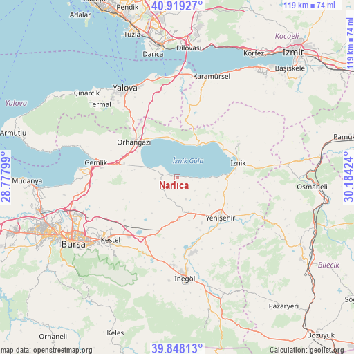
Narlıca GPS coordinates[2]
40° 23' 8.988" North, 29° 28' 51.996" East
| Map corner | latitude | longitude |
|---|---|---|
| Upper-left | 40.91927°, | 28.77799° |
| Center: | 40.38583°, | 29.48111° |
| Lower-right: | 39.84813°, | 30.18424° |
| Map W x H: | 119.1×119.1 km | = 74×74mi |
| max Lat: | 42.02683° ⇑24.4% North |
| Narlıca: | 40.38583° |
| min Lat: | ⇓75.6% South 35.9025° |
| min Long | Narlıca | max Long |
| 25.90902° | 29.48111° | 44.60099° |
| W 20.3%⇐ | ⇒79.7% E |
Elevation
Elevation of Narlıca is 203 m = 666 ft, and this is 514.4 m = 1688 ft below average elevation for this country.
| Max E: |
2682 m = 8799 ft | 73.4% |
| Avg. | 717.4 m = 2354 ft | |
| Narlıca | 203 m = 666 ft | |
Min E: |
0 m = 0 ft | 26.6% |
See also: Turkey elevation on elevation.city.
Geographical zone
Narlıca is located in North temperate zone (between Tropic of Cancer and the Arctic Circle). Distance of this Northern Tropic circle is 1884.6 km =1171 mi to South.| Distance of | km | miles | from Narlıca |
|---|---|---|---|
| North Pole | 5516.6 | 3427.9 | to North |
| Arctic Circle | 2910.7 | 1808.6 | to North |
| Tropic Cancer | 1884.6 | 1171 | to South |
| Equator | 4490.5 | 2790.3 | to South |


Nearby cities:
15 places around Narlıca: (largest is in red/bold)
• Balarim
9.3 km =5.8 mi,  98°
98°
• Boyalıca
12.6 km =7.8 mi,  32°
32°
• Dırazali
19.2 km =11.9 mi,  86°
86°
• Elbeyli
23.4 km =14.5 mi,  61°
61°
• Gölcük
15 km =9.3 mi,  215°
215°
• Orhangazi
18.6 km =11.6 mi,  308°
308°
• Orhaniye
20.2 km =12.6 mi,  48°
48°
• Seçköy
25.1 km =15.6 mi,  254°
254°
• Sölöz
5.6 km =3.5 mi,  280°
280°
• Yeniköy
19.8 km =12.3 mi,  327°
327°
• Yenişehir
19.9 km =12.4 mi,  132°
132°
• Çakırca
18.1 km =11.2 mi, 58°
• Çakırlı
14.9 km =9.3 mi,  350°
350°
• Çukurköy
25.1 km =15.6 mi, 346°
• İznik
20.9 km =13 mi,  76°
76°
Sources, notices
• [Note1] Compared only with cities in Turkey existing in our database
• [Src1] Map data: © OpenStreetMap contributors (CC-BY-SA)
• [Src2] Other city data from geonames.org with taken over terms of usage.
• [Src3] Geographical zone / Annual Mean Temperature by Robert A. Rohde @ Wikipedia
