Eflani geodata
Eflani (Karabük) is a seat of a second-order administrative division; located in Turkey in Europe/Istanbul (GMT+3) time zone. With population of 4,425 people, there are 757 cities with bigger population in this country. Compared to other cities in Turkey, 96.7% of cities are located further ↓South; 62.3% of cities are located further →East and 61.7% of cities have lower elevation than Eflani. Note1


Eflani GPS coordinates[2]
41° 25' 22.404" North, 32° 57' 27.396" East
| Map corner | latitude | longitude |
|---|---|---|
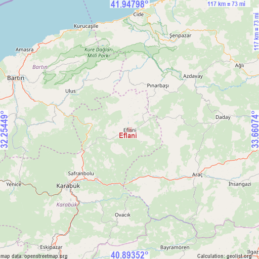
| Upper-left | 41.94798°, | 32.25449° |
| Center: | 41.42289°, | 32.95761° |
| Lower-right: | 40.89352°, | 33.66074° |
| Map W x H: | 117.2×117.2 km | = 72.8×72.8mi |
| max Lat: | 42.02683° ⇑3.3% North |
| Eflani: | 41.42289° |
| min Lat: | ⇓96.7% South 35.9025° |
| min Long | Eflani | max Long |
| 25.90902° | 32.95761° | 44.60099° |
| W 37.7%⇐ | ⇒62.3% E |
Elevation
Elevation of Eflani is 908 m = 2979 ft, and this is 190.6 m = 625 ft above average elevation for this country.
| Max E: |
2682 m = 8799 ft | 38.3% |
| Eflani | 908 m 2979 ft | |
| Avg. | 717.4 m = 2354 ft | |
Min E: |
0 m = 0 ft | 61.7% |
See also: Turkey elevation on elevation.city.
Geographical zone
Eflani is located in North temperate zone (between Tropic of Cancer and the Arctic Circle). Distance of this Northern Tropic circle is 1999.9 km =1242.7 mi to South.| Distance of | km | miles | from Eflani |
|---|---|---|---|
| North Pole | 5401.3 | 3356.2 | to North |
| Arctic Circle | 2795.4 | 1737 | to North |
| Tropic Cancer | 1999.9 | 1242.7 | to South |
| Equator | 4605.8 | 2861.9 | to South |


Nearby cities:
15 places around Eflani: (largest is in red/bold)
• Akkaya
49.5 km =30.8 mi,  117°
117°
• Araç
36.9 km =22.9 mi, 123°
• Arıt
40.4 km =25.1 mi,  316°
316°
• Azdavay
37.5 km =23.3 mi,  49°
49°
• Daday
42.9 km =26.7 mi,  81°
81°
• Karabük
36.7 km =22.8 mi,  228°
228°
• Kumluca
40.9 km =25.4 mi,  273°
273°
• Kurucaşile
50.3 km =31.3 mi,  336°
336°
• Ovacuma
17.2 km =10.7 mi,  279°
279°
• Ovacık
38.6 km =24 mi,  184°
184°
• Pınarbaşı
23.8 km =14.8 mi,  32°
32°
• Safranbolu
29.1 km =18.1 mi, 228°
• Ulus
31.9 km =19.8 mi,  304°
304°
• İğdir
26.5 km =16.5 mi,  145°
145°
• Şenpazar
48.6 km =30.2 mi, 27°
Sources, notices
• [Note1] Compared only with cities in Turkey existing in our database
• [Src1] Map data: © OpenStreetMap contributors (CC-BY-SA)
• [Src2] Other city data from geonames.org with taken over terms of usage.
• [Src3] Geographical zone / Annual Mean Temperature by Robert A. Rohde @ Wikipedia
