İznik geodata
İznik (Bursa) is a seat of a second-order administrative division; located in Turkey in Europe/Istanbul (GMT+3) time zone. With population of 22,230 people, there are 309 cities with bigger population in this country. Compared to other cities in Turkey, 76.6% of cities are located further ↓South; 77.7% of cities are located further →East and 81.6% of cities have higher elevation than İznik. Note1


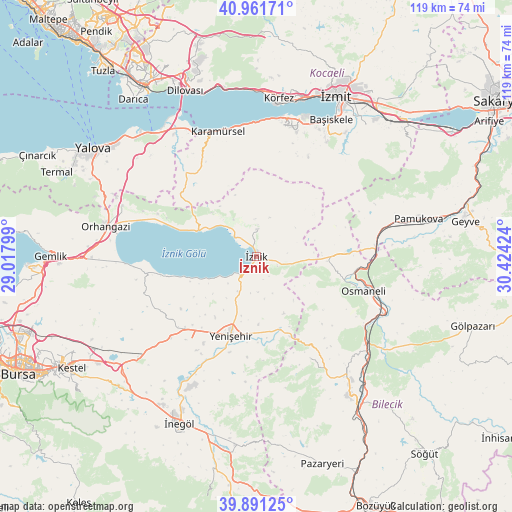
İznik GPS coordinates[2]
40° 25' 42.996" North, 29° 43' 15.996" East
| Map corner | latitude | longitude |
|---|---|---|
| Upper-left | 40.96171°, | 29.01799° |
| Center: | 40.42861°, | 29.72111° |
| Lower-right: | 39.89125°, | 30.42424° |
| Map W x H: | 119×119 km | = 73.9×73.9mi |
| max Lat: | 42.02683° ⇑23.4% North |
| İznik: | 40.42861° |
| min Lat: | ⇓76.6% South 35.9025° |
| min Long | İznik | max Long |
| 25.90902° | 29.72111° | 44.60099° |
| W 22.3%⇐ | ⇒77.7% E |
Elevation
Elevation of İznik is 99 m = 325 ft, and this is 618.4 m = 2029 ft below average elevation for this country.
| Max E: |
2682 m = 8799 ft | 81.6% |
| Avg. | 717.4 m = 2354 ft | |
| İznik | 99 m = 325 ft | |
Min E: |
0 m = 0 ft | 18.4% |
See also: Turkey elevation on elevation.city.
Geographical zone
İznik is located in North temperate zone (between Tropic of Cancer and the Arctic Circle). Distance of this Northern Tropic circle is 1889.3 km =1174 mi to South.| Distance of | km | miles | from İznik |
|---|---|---|---|
| North Pole | 5511.8 | 3424.9 | to North |
| Arctic Circle | 2905.9 | 1805.6 | to North |
| Tropic Cancer | 1889.3 | 1174 | to South |
| Equator | 4495.2 | 2793.2 | to South |


Nearby cities:
15 places around İznik: (largest is in red/bold)
• Balarim
12.6 km =7.8 mi,  241°
241°
• Boyalıca
14.8 km =9.2 mi,  293°
293°
• Dırazali
3.8 km =2.4 mi,  197°
197°
• Elbeyli
6.4 km =4 mi,  2°
2°
• Elmalı
16.7 km =10.4 mi,  54°
54°
• Kaynarca
9 km =5.6 mi,  100°
100°
• Narlıca
20.9 km =13 mi,  256°
256°
• Orhaniye
10.1 km =6.3 mi,  328°
328°
• Osmaneli
26.1 km =16.2 mi,  107°
107°
• Sansarak
11.3 km =7 mi, 53°
• Tacir
10.9 km =6.8 mi,  8°
8°
• Yalakdere
23.9 km =14.9 mi, 325°
• Yenişehir
19.1 km =11.9 mi, 197°
• Çakırca
6.8 km =4.2 mi,  313°
313°
• Çakırlı
24.8 km =15.4 mi, 293°
Sources, notices
• [Note1] Compared only with cities in Turkey existing in our database
• [Src1] Map data: © OpenStreetMap contributors (CC-BY-SA)
• [Src2] Other city data from geonames.org with taken over terms of usage.
• [Src3] Geographical zone / Annual Mean Temperature by Robert A. Rohde @ Wikipedia
