Elbeyli geodata
Elbeyli (Bursa) is a populated place; located in Turkey in Europe/Istanbul (GMT+3) time zone. With population of 2,569 people, there are 896 cities with bigger population in this country. Compared to other cities in Turkey, 77.4% of cities are located further ↓South; 77.7% of cities are located further →East and 73.9% of cities have higher elevation than Elbeyli. Note1


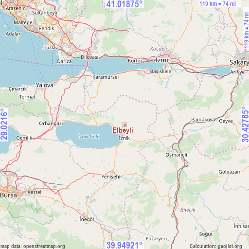
Elbeyli GPS coordinates[2]
40° 29' 9.996" North, 29° 43' 28.992" East
| Map corner | latitude | longitude |
|---|---|---|
| Upper-left | 41.01875°, | 29.0216° |
| Center: | 40.48611°, | 29.72472° |
| Lower-right: | 39.94921°, | 30.42785° |
| Map W x H: | 118.9×118.9 km | = 73.9×73.9mi |
| max Lat: | 42.02683° ⇑22.6% North |
| Elbeyli: | 40.48611° |
| min Lat: | ⇓77.4% South 35.9025° |
| min Long | Elbeyli | max Long |
| 25.90902° | 29.72472° | 44.60099° |
| W 22.3%⇐ | ⇒77.7% E |
Elevation
Elevation of Elbeyli is 191 m = 627 ft, and this is 526.4 m = 1727 ft below average elevation for this country.
| Max E: |
2682 m = 8799 ft | 73.9% |
| Avg. | 717.4 m = 2354 ft | |
| Elbeyli | 191 m = 627 ft | |
Min E: |
0 m = 0 ft | 26.1% |
See also: Turkey elevation on elevation.city.
Geographical zone
Elbeyli is located in North temperate zone (between Tropic of Cancer and the Arctic Circle). Distance of this Northern Tropic circle is 1895.7 km =1177.9 mi to South.| Distance of | km | miles | from Elbeyli |
|---|---|---|---|
| North Pole | 5505.4 | 3420.9 | to North |
| Arctic Circle | 2899.5 | 1801.7 | to North |
| Tropic Cancer | 1895.7 | 1177.9 | to South |
| Equator | 4501.6 | 2797.2 | to South |


Nearby cities:
15 places around Elbeyli: (largest is in red/bold)
• Balarim
16.9 km =10.5 mi,  222°
222°
• Boyalıca
13.9 km =8.6 mi,  268°
268°
• Dereköy
24 km =14.9 mi,  325°
325°
• Dırazali
10.1 km =6.3 mi,  188°
188°
• Elmalı
13.6 km =8.5 mi,  76°
76°
• Kaynarca
11.7 km =7.3 mi,  133°
133°
• Narlıca
23.4 km =14.5 mi,  241°
241°
• Nüzhetiye
20.7 km =12.9 mi,  34°
34°
• Orhaniye
5.9 km =3.7 mi,  292°
292°
• Sansarak
8.9 km =5.5 mi,  88°
88°
• Tacir
4.6 km =2.9 mi,  16°
16°
• Yalakdere
19.2 km =11.9 mi,  314°
314°
• Çakırca
5.5 km =3.4 mi,  251°
251°
• Çakırlı
23.3 km =14.5 mi,  278°
278°
• İznik
6.4 km =4 mi,  182°
182°
Sources, notices
• [Note1] Compared only with cities in Turkey existing in our database
• [Src1] Map data: © OpenStreetMap contributors (CC-BY-SA)
• [Src2] Other city data from geonames.org with taken over terms of usage.
• [Src3] Geographical zone / Annual Mean Temperature by Robert A. Rohde @ Wikipedia
