Kumbağ geodata
Kumbağ (Tekirdağ) is a populated place; located in Turkey in Europe/Istanbul (GMT+3) time zone. With population of 2,069 people, there are 943 cities with bigger population in this country. Compared to other cities in Turkey, 85.8% of cities are located further ↓South; 93.7% of cities are located further →East and 96.8% of cities have higher elevation than Kumbağ. Note1


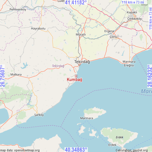
Kumbağ GPS coordinates[2]
40° 52' 56.496" North, 27° 27' 33.084" East
| Map corner | latitude | longitude |
|---|---|---|
| Upper-left | 41.41182°, | 26.75607° |
| Center: | 40.88236°, | 27.45919° |
| Lower-right: | 40.34863°, | 28.16232° |
| Map W x H: | 118.2×118.2 km | = 73.4×73.4mi |
| max Lat: | 42.02683° ⇑14.2% North |
| Kumbağ: | 40.88236° |
| min Lat: | ⇓85.8% South 35.9025° |
| min Long | Kumbağ | max Long |
| 25.90902° | 27.45919° | 44.60099° |
| W 6.3%⇐ | ⇒93.7% E |
Elevation
Elevation of Kumbağ is 12 m = 39 ft, and this is 705.4 m = 2314 ft below average elevation for this country.
| Max E: |
2682 m = 8799 ft | 96.8% |
| Avg. | 717.4 m = 2354 ft | |
| Kumbağ | 12 m = 39 ft | |
Min E: |
0 m = 0 ft | 3.2% |
See also: Turkey elevation on elevation.city.
Geographical zone
Kumbağ is located in North temperate zone (between Tropic of Cancer and the Arctic Circle). Distance of this Northern Tropic circle is 1939.8 km =1205.3 mi to South.| Distance of | km | miles | from Kumbağ |
|---|---|---|---|
| North Pole | 5461.4 | 3393.6 | to North |
| Arctic Circle | 2855.5 | 1774.3 | to North |
| Tropic Cancer | 1939.8 | 1205.3 | to South |
| Equator | 4545.7 | 2824.6 | to South |


Nearby cities:
15 places around Kumbağ: (largest is in red/bold)
• Ballı
34.4 km =21.4 mi,  260°
260°
• Banarlı
23 km =14.3 mi,  333°
333°
• Büyükkarıştıran
47 km =29.2 mi,  8°
8°
• Dambaslar
41.9 km =26 mi,  335°
335°
• Malkara
46.9 km =29.1 mi,  271°
271°
• Marmara
33.9 km =21.1 mi,  166°
166°
• Marmara Ereğlisi
42.8 km =26.6 mi,  76°
76°
• Marmaracık
43.7 km =27.2 mi,  34°
34°
• Muratlı
32.4 km =20.1 mi, 5°
• Susuzmüsellim
40.7 km =25.3 mi,  306°
306°
• Tekirdağ
11.5 km =7.1 mi,  22°
22°
• Yürük
33.5 km =20.8 mi,  280°
280°
• Çorlu
42 km =26.1 mi,  42°
42°
• İnecik
16.1 km =10 mi,  291°
291°
• Şarköy
41.6 km =25.8 mi,  224°
224°
Sources, notices
• [Note1] Compared only with cities in Turkey existing in our database
• [Src1] Map data: © OpenStreetMap contributors (CC-BY-SA)
• [Src2] Other city data from geonames.org with taken over terms of usage.
• [Src3] Geographical zone / Annual Mean Temperature by Robert A. Rohde @ Wikipedia
