Amasya geodata
Amasya is a seat of a first-order administrative division; located in Turkey in Europe/Istanbul (GMT+3) time zone. With population of 82,896 people, there are 107 cities with bigger population in this country. Compared to other cities in Turkey, 80% of cities are located further ↓South; 50.6% of cities are located further →East and 65.3% of cities have higher elevation than Amasya. Note1


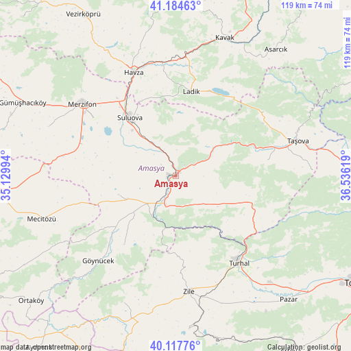
Amasya GPS coordinates[2]
40° 39' 11.988" North, 35° 49' 59.016" East
| Map corner | latitude | longitude |
|---|---|---|
| Upper-left | 41.18463°, | 35.12994° |
| Center: | 40.65333°, | 35.83306° |
| Lower-right: | 40.11776°, | 36.53619° |
| Map W x H: | 118.6×118.6 km | = 73.7×73.7mi |
| max Lat: | 42.02683° ⇑20% North |
| Amasya: | 40.65333° |
| min Lat: | ⇓80% South 35.9025° |
| min Long | Amasya | max Long |
| 25.90902° | 35.83306° | 44.60099° |
| W 49.4%⇐ | ⇒50.6% E |
Elevation
Elevation of Amasya is 402 m = 1319 ft, and this is 315.4 m = 1035 ft below average elevation for this country.
| Max E: |
2682 m = 8799 ft | 65.3% |
| Avg. | 717.4 m = 2354 ft | |
| Amasya | 402 m = 1319 ft | |
Min E: |
0 m = 0 ft | 34.7% |
See also: Amasya elevation on elevation.city.
Geographical zone
Amasya is located in North temperate zone (between Tropic of Cancer and the Arctic Circle). Distance of this Northern Tropic circle is 1914.3 km =1189.5 mi to South.| Distance of | km | miles | from Amasya |
|---|---|---|---|
| North Pole | 5486.8 | 3409.3 | to North |
| Arctic Circle | 2880.9 | 1790.1 | to North |
| Tropic Cancer | 1914.3 | 1189.5 | to South |
| Equator | 4520.2 | 2808.7 | to South |


Nearby cities:
15 places around Amasya: (largest is in red/bold)
• Akdağ
13.7 km =8.5 mi,  61°
61°
• Destek
36.5 km =22.7 mi,  53°
53°
• Doğantepe
20.3 km =12.6 mi,  252°
252°
• Ezinepazarı
27.5 km =17.1 mi,  109°
109°
• Gediksaray
29 km =18 mi,  217°
217°
• Göynücek
38.4 km =23.9 mi, 222°
• Havza
38.1 km =23.7 mi,  337°
337°
• Ladik
29 km =18 mi,  9°
9°
• Merzifon
39.6 km =24.6 mi,  308°
308°
• Sarıbuğday
33.2 km =20.6 mi,  288°
288°
• Suluova
25.2 km =15.7 mi,  321°
321°
• Tekke
31.1 km =19.3 mi,  77°
77°
• Turhal
36.2 km =22.5 mi,  144°
144°
• Zile
39.2 km =24.4 mi,  173°
173°
• Şeyhli
35.6 km =22.1 mi,  32°
32°
Sources, notices
• [Note1] Compared only with cities in Turkey existing in our database
• [Src1] Map data: © OpenStreetMap contributors (CC-BY-SA)
• [Src2] Other city data from geonames.org with taken over terms of usage.
• [Src3] Geographical zone / Annual Mean Temperature by Robert A. Rohde @ Wikipedia
