Vezirköprü geodata
Vezirköprü (Samsun) is a seat of a second-order administrative division; located in Turkey in Europe/Istanbul (GMT+3) time zone. With population of 25,155 people, there are 284 cities with bigger population in this country. Compared to other cities in Turkey, 93% of cities are located further ↓South; 52.4% of cities are located further →East and 68.9% of cities have higher elevation than Vezirköprü. Note1


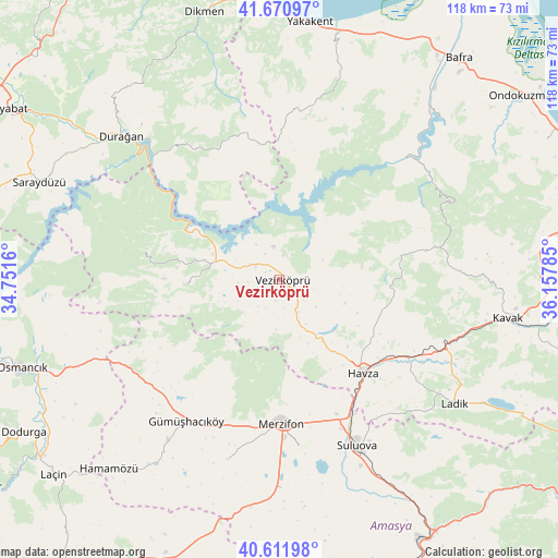
Vezirköprü GPS coordinates[2]
41° 8' 36.996" North, 35° 27' 16.992" East
| Map corner | latitude | longitude |
|---|---|---|
| Upper-left | 41.67097°, | 34.7516° |
| Center: | 41.14361°, | 35.45472° |
| Lower-right: | 40.61198°, | 36.15785° |
| Map W x H: | 117.7×117.7 km | = 73.1×73.1mi |
| max Lat: | 42.02683° ⇑7% North |
| Vezirköprü: | 41.14361° |
| min Lat: | ⇓93% South 35.9025° |
| min Long | Vezirköprü | max Long |
| 25.90902° | 35.45472° | 44.60099° |
| W 47.6%⇐ | ⇒52.4% E |
Elevation
Elevation of Vezirköprü is 335 m = 1099 ft, and this is 382.4 m = 1255 ft below average elevation for this country.
| Max E: |
2682 m = 8799 ft | 68.9% |
| Avg. | 717.4 m = 2354 ft | |
| Vezirköprü | 335 m = 1099 ft | |
Min E: |
0 m = 0 ft | 31.1% |
See also: Turkey elevation on elevation.city.
Geographical zone
Vezirköprü is located in North temperate zone (between Tropic of Cancer and the Arctic Circle). Distance of this Northern Tropic circle is 1968.8 km =1223.4 mi to South.| Distance of | km | miles | from Vezirköprü |
|---|---|---|---|
| North Pole | 5432.3 | 3375.5 | to North |
| Arctic Circle | 2826.4 | 1756.2 | to North |
| Tropic Cancer | 1968.8 | 1223.4 | to South |
| Equator | 4574.7 | 2842.6 | to South |


Nearby cities:
15 places around Vezirköprü: (largest is in red/bold)
• Alıcık
39.5 km =24.5 mi,  196°
196°
• Beşpınar
19.9 km =12.4 mi,  268°
268°
• Gümüş
41.2 km =25.6 mi,  215°
215°
• Gümüşhacıköy
36.2 km =22.5 mi,  213°
213°
• Havza
25.9 km =16.1 mi,  137°
137°
• Kolay
42.1 km =26.2 mi,  43°
43°
• Köprübaşı
11.9 km =7.4 mi,  154°
154°
• Ladik
44.9 km =27.9 mi,  125°
125°
• Merzifon
30.1 km =18.7 mi,  178°
178°
• Mezraa
28.9 km =18 mi,  281°
281°
• Saraycık
35.9 km =22.3 mi,  233°
233°
• Sarıbuğday
44 km =27.3 mi, 179°
• Suluova
38.3 km =23.8 mi, 154°
• Çakıralan
25.7 km =16 mi,  83°
83°
• Çerçiler
33.3 km =20.7 mi,  326°
326°
Sources, notices
• [Note1] Compared only with cities in Turkey existing in our database
• [Src1] Map data: © OpenStreetMap contributors (CC-BY-SA)
• [Src2] Other city data from geonames.org with taken over terms of usage.
• [Src3] Geographical zone / Annual Mean Temperature by Robert A. Rohde @ Wikipedia
