Havza geodata
Havza (Samsun) is a seat of a second-order administrative division; located in Turkey in Europe/Istanbul (GMT+3) time zone. With population of 21,500 people, there are 315 cities with bigger population in this country. Compared to other cities in Turkey, 88.2% of cities are located further ↓South; 51.1% of cities are located further →East and 53.1% of cities have higher elevation than Havza. Note1


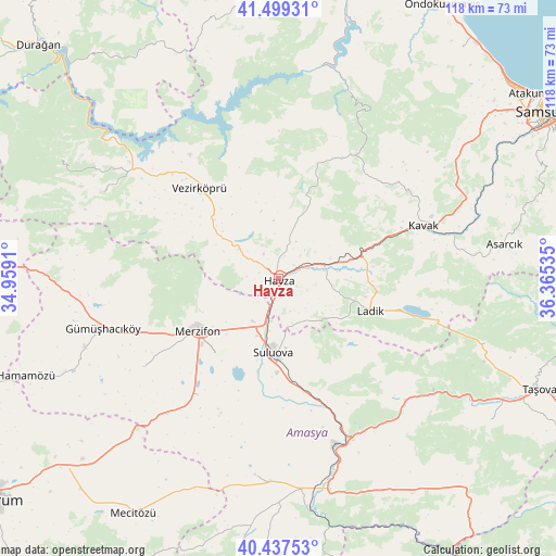
Havza GPS coordinates[2]
40° 58' 14.016" North, 35° 39' 43.992" East
| Map corner | latitude | longitude |
|---|---|---|
| Upper-left | 41.49931°, | 34.9591° |
| Center: | 40.97056°, | 35.66222° |
| Lower-right: | 40.43753°, | 36.36535° |
| Map W x H: | 118.1×118.1 km | = 73.4×73.4mi |
| max Lat: | 42.02683° ⇑11.8% North |
| Havza: | 40.97056° |
| min Lat: | ⇓88.2% South 35.9025° |
| min Long | Havza | max Long |
| 25.90902° | 35.66222° | 44.60099° |
| W 48.9%⇐ | ⇒51.1% E |
Elevation
Elevation of Havza is 632 m = 2073 ft, and this is 85.4 m = 280 ft below average elevation for this country.
| Max E: |
2682 m = 8799 ft | 53.1% |
| Avg. | 717.4 m = 2354 ft | |
| Havza | 632 m = 2073 ft | |
Min E: |
0 m = 0 ft | 46.9% |
See also: Turkey elevation on elevation.city.
Geographical zone
Havza is located in North temperate zone (between Tropic of Cancer and the Arctic Circle). Distance of this Northern Tropic circle is 1949.6 km =1211.4 mi to South.| Distance of | km | miles | from Havza |
|---|---|---|---|
| North Pole | 5451.6 | 3387.5 | to North |
| Arctic Circle | 2845.7 | 1768.2 | to North |
| Tropic Cancer | 1949.6 | 1211.4 | to South |
| Equator | 4555.5 | 2830.7 | to South |


Nearby cities:
15 places around Havza: (largest is in red/bold)
• Akdağ
39 km =24.2 mi,  137°
137°
• Alıcık
34.1 km =21.2 mi,  236°
236°
• Amasya
38.1 km =23.7 mi,  157°
157°
• Beşpınar
41.7 km =25.9 mi,  296°
296°
• Doğantepe
41.7 km =25.9 mi,  186°
186°
• Gümüşhacıköy
39.1 km =24.3 mi,  253°
253°
• Kavak
34.1 km =21.2 mi,  69°
69°
• Köprübaşı
14.9 km =9.3 mi,  305°
305°
• Ladik
20.4 km =12.7 mi,  109°
109°
• Merzifon
19.9 km =12.4 mi, 237°
• Sarıbuğday
30 km =18.6 mi,  214°
214°
• Suluova
15.5 km =9.6 mi,  184°
184°
• Vezirköprü
25.9 km =16.1 mi,  317°
317°
• Çakıralan
23.5 km =14.6 mi,  20°
20°
• Şeyhli
34.1 km =21.2 mi,  99°
99°
Sources, notices
• [Note1] Compared only with cities in Turkey existing in our database
• [Src1] Map data: © OpenStreetMap contributors (CC-BY-SA)
• [Src2] Other city data from geonames.org with taken over terms of usage.
• [Src3] Geographical zone / Annual Mean Temperature by Robert A. Rohde @ Wikipedia
