Ladik geodata
Ladik (Samsun) is a seat of a second-order administrative division; located in Turkey in Europe/Istanbul (GMT+3) time zone. With population of 9,542 people, there are 520 cities with bigger population in this country. Compared to other cities in Turkey, 86.5% of cities are located further ↓South; 50.3% of cities are located further →East and 63.7% of cities have lower elevation than Ladik. Note1


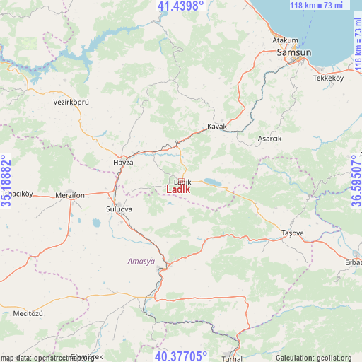
Ladik GPS coordinates[2]
40° 54' 38.016" North, 35° 53' 30.984" East
| Map corner | latitude | longitude |
|---|---|---|
| Upper-left | 41.4398°, | 35.18882° |
| Center: | 40.91056°, | 35.89194° |
| Lower-right: | 40.37705°, | 36.59507° |
| Map W x H: | 118.2×118.2 km | = 73.4×73.4mi |
| max Lat: | 42.02683° ⇑13.5% North |
| Ladik: | 40.91056° |
| min Lat: | ⇓86.5% South 35.9025° |
| min Long | Ladik | max Long |
| 25.90902° | 35.89194° | 44.60099° |
| W 49.7%⇐ | ⇒50.3% E |
Elevation
Elevation of Ladik is 940 m = 3084 ft, and this is 222.6 m = 730 ft above average elevation for this country.
| Max E: |
2682 m = 8799 ft | 36.3% |
| Ladik | 940 m 3084 ft | |
| Avg. | 717.4 m = 2354 ft | |
Min E: |
0 m = 0 ft | 63.7% |
See also: Turkey elevation on elevation.city.
Geographical zone
Ladik is located in North temperate zone (between Tropic of Cancer and the Arctic Circle). Distance of this Northern Tropic circle is 1942.9 km =1207.3 mi to South.| Distance of | km | miles | from Ladik |
|---|---|---|---|
| North Pole | 5458.2 | 3391.6 | to North |
| Arctic Circle | 2852.3 | 1772.3 | to North |
| Tropic Cancer | 1942.9 | 1207.3 | to South |
| Equator | 4548.8 | 2826.5 | to South |


Nearby cities:
15 places around Ladik: (largest is in red/bold)
• Akdağ
23.1 km =14.4 mi,  162°
162°
• Amasya
29 km =18 mi,  189°
189°
• Asarcık
32 km =19.9 mi,  64°
64°
• Destek
25.5 km =15.8 mi,  106°
106°
• Doğantepe
42.4 km =26.3 mi,  214°
214°
• Havza
20.4 km =12.7 mi,  289°
289°
• Kavak
22.5 km =14 mi,  34°
34°
• Köprübaşı
35 km =21.7 mi,  295°
295°
• Merzifon
36.3 km =22.6 mi,  263°
263°
• Sarıbuğday
40.6 km =25.2 mi,  243°
243°
• Suluova
22.3 km =13.9 mi,  246°
246°
• Taşova
39.9 km =24.8 mi, 114°
• Tekke
33.3 km =20.7 mi,  130°
130°
• Çakıralan
30.7 km =19.1 mi,  338°
338°
• Şeyhli
14.5 km =9 mi,  84°
84°
Sources, notices
• [Note1] Compared only with cities in Turkey existing in our database
• [Src1] Map data: © OpenStreetMap contributors (CC-BY-SA)
• [Src2] Other city data from geonames.org with taken over terms of usage.
• [Src3] Geographical zone / Annual Mean Temperature by Robert A. Rohde @ Wikipedia
