Bandırma geodata
Bandırma (Balıkesir) is a seat of a second-order administrative division; located in Turkey in Europe/Istanbul (GMT+3) time zone. With population of 107,631 people, there are 79 cities with bigger population in this country. Compared to other cities in Turkey, 75.3% of cities are located further ↓South; 90.5% of cities are located further →East and 89.9% of cities have higher elevation than Bandırma. Note1


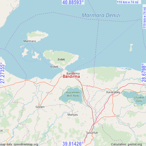
Bandırma GPS coordinates[2]
40° 21' 7.992" North, 27° 58' 36.012" East
| Map corner | latitude | longitude |
|---|---|---|
| Upper-left | 40.88593°, | 27.27355° |
| Center: | 40.35222°, | 27.97667° |
| Lower-right: | 39.81426°, | 28.6798° |
| Map W x H: | 119.2×119.2 km | = 74.1×74.1mi |
| max Lat: | 42.02683° ⇑24.7% North |
| Bandırma: | 40.35222° |
| min Lat: | ⇓75.3% South 35.9025° |
| min Long | Bandırma | max Long |
| 25.90902° | 27.97667° | 44.60099° |
| W 9.5%⇐ | ⇒90.5% E |
Elevation
Elevation of Bandırma is 40 m = 131 ft, and this is 677.4 m = 2222 ft below average elevation for this country.
| Max E: |
2682 m = 8799 ft | 89.9% |
| Avg. | 717.4 m = 2354 ft | |
| Bandırma | 40 m = 131 ft | |
Min E: |
0 m = 0 ft | 10.1% |
See also: Bandırma elevation on elevation.city.
Geographical zone
Bandırma is located in North temperate zone (between Tropic of Cancer and the Arctic Circle). Distance of this Northern Tropic circle is 1880.8 km =1168.7 mi to South.| Distance of | km | miles | from Bandırma |
|---|---|---|---|
| North Pole | 5520.3 | 3430.2 | to North |
| Arctic Circle | 2914.4 | 1810.9 | to North |
| Tropic Cancer | 1880.8 | 1168.7 | to South |
| Equator | 4486.7 | 2787.9 | to South |


Nearby cities:
15 places around Bandırma: (largest is in red/bold)
• Aksakal
25.3 km =15.7 mi,  154°
154°
• Buğdaylı
22.9 km =14.2 mi,  229°
229°
• Darıca
38.1 km =23.7 mi,  194°
194°
• Edincik
9.8 km =6.1 mi,  263°
263°
• Erdek
16.4 km =10.2 mi,  288°
288°
• Göbel
39.7 km =24.7 mi,  158°
158°
• Gönen
38.8 km =24.1 mi,  224°
224°
• Karacabey
36.1 km =22.4 mi,  115°
115°
• Manyas
34 km =21.1 mi,  180°
180°
• Marmara
44.1 km =27.4 mi,  306°
306°
• Sarıköy
36.1 km =22.4 mi,  243°
243°
• Sinekçi
49.2 km =30.6 mi, 259°
• Tatkavaklı
48.5 km =30.1 mi,  136°
136°
• Tütüncü
38.5 km =23.9 mi,  214°
214°
• Şevketiye
30.8 km =19.1 mi,  200°
200°
Sources, notices
• [Note1] Compared only with cities in Turkey existing in our database
• [Src1] Map data: © OpenStreetMap contributors (CC-BY-SA)
• [Src2] Other city data from geonames.org with taken over terms of usage.
• [Src3] Geographical zone / Annual Mean Temperature by Robert A. Rohde @ Wikipedia
