Yürük geodata
Yürük (Tekirdağ) is a seat of a third-order administrative division; located in Turkey in Europe/Istanbul (GMT+3) time zone. In our database, there are 1323 cities with bigger population. Compared to other cities in Turkey, 87.1% of cities are located further ↓South; 97% of cities are located further →East and 73.8% of cities have higher elevation than Yürük. Note1


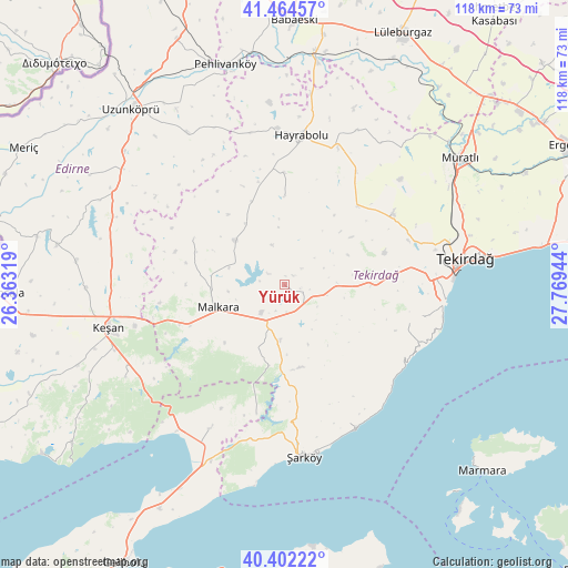
Yürük GPS coordinates[2]
40° 56' 7.908" North, 27° 3' 58.716" East
| Map corner | latitude | longitude |
|---|---|---|
| Upper-left | 41.46457°, | 26.36319° |
| Center: | 40.93553°, | 27.06631° |
| Lower-right: | 40.40222°, | 27.76944° |
| Map W x H: | 118.1×118.1 km | = 73.4×73.4mi |
| max Lat: | 42.02683° ⇑12.9% North |
| Yürük: | 40.93553° |
| min Lat: | ⇓87.1% South 35.9025° |
| min Long | Yürük | max Long |
| 25.90902° | 27.06631° | 44.60099° |
| W 3%⇐ | ⇒97% E |
Elevation
Elevation of Yürük is 197 m = 646 ft, and this is 520.4 m = 1707 ft below average elevation for this country.
| Max E: |
2682 m = 8799 ft | 73.8% |
| Avg. | 717.4 m = 2354 ft | |
| Yürük | 197 m = 646 ft | |
Min E: |
0 m = 0 ft | 26.2% |
See also: Turkey elevation on elevation.city.
Geographical zone
Yürük is located in North temperate zone (between Tropic of Cancer and the Arctic Circle). Distance of this Northern Tropic circle is 1945.7 km =1209 mi to South.| Distance of | km | miles | from Yürük |
|---|---|---|---|
| North Pole | 5455.5 | 3389.9 | to North |
| Arctic Circle | 2849.6 | 1770.7 | to North |
| Tropic Cancer | 1945.7 | 1209 | to South |
| Equator | 4551.6 | 2828.2 | to South |


Nearby cities:
15 places around Yürük: (largest is in red/bold)
• Ballı
11.7 km =7.3 mi,  184°
184°
• Banarlı
26.9 km =16.7 mi,  57°
57°
• Dambaslar
35.5 km =22.1 mi,  25°
25°
• Evreşe
33.6 km =20.9 mi,  207°
207°
• Hamidiye
41.4 km =25.7 mi,  305°
305°
• Hayrabolu
31.1 km =19.3 mi,  6°
6°
• Keşan
37.7 km =23.4 mi,  256°
256°
• Kumbağ
33.5 km =20.8 mi,  100°
100°
• Malkara
14.8 km =9.2 mi,  249°
249°
• Susuzmüsellim
18.2 km =11.3 mi,  0°
0°
• Tekirdağ
37.6 km =23.4 mi,  82°
82°
• Çöpköy
37.6 km =23.4 mi,  327°
327°
• İnecik
18 km =11.2 mi,  90°
90°
• Şahin
21.1 km =13.1 mi,  297°
297°
• Şarköy
36 km =22.4 mi,  173°
173°
Sources, notices
• [Note1] Compared only with cities in Turkey existing in our database
• [Src1] Map data: © OpenStreetMap contributors (CC-BY-SA)
• [Src2] Other city data from geonames.org with taken over terms of usage.
• [Src3] Geographical zone / Annual Mean Temperature by Robert A. Rohde @ Wikipedia
