Ballı geodata
Ballı (Tekirdağ) is a seat of a third-order administrative division; located in Turkey in Europe/Istanbul (GMT+3) time zone. In our database, there are 1323 cities with bigger population. Compared to other cities in Turkey, 84.3% of cities are located further ↓South; 97% of cities are located further →East and 77.4% of cities have higher elevation than Ballı. Note1


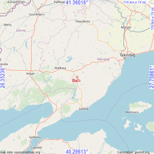
Ballı GPS coordinates[2]
40° 49' 49.008" North, 27° 3' 19.728" East
| Map corner | latitude | longitude |
|---|---|---|
| Upper-left | 41.36016°, | 26.35236° |
| Center: | 40.83028°, | 27.05548° |
| Lower-right: | 40.29613°, | 27.75861° |
| Map W x H: | 118.3×118.3 km | = 73.5×73.5mi |
| max Lat: | 42.02683° ⇑15.7% North |
| Ballı: | 40.83028° |
| min Lat: | ⇓84.3% South 35.9025° |
| min Long | Ballı | max Long |
| 25.90902° | 27.05548° | 44.60099° |
| W 3%⇐ | ⇒97% E |
Elevation
Elevation of Ballı is 147 m = 482 ft, and this is 570.4 m = 1871 ft below average elevation for this country.
| Max E: |
2682 m = 8799 ft | 77.4% |
| Avg. | 717.4 m = 2354 ft | |
| Ballı | 147 m = 482 ft | |
Min E: |
0 m = 0 ft | 22.6% |
See also: Turkey elevation on elevation.city.
Geographical zone
Ballı is located in North temperate zone (between Tropic of Cancer and the Arctic Circle). Distance of this Northern Tropic circle is 1934 km =1201.7 mi to South.| Distance of | km | miles | from Ballı |
|---|---|---|---|
| North Pole | 5467.2 | 3397.2 | to North |
| Arctic Circle | 2861.3 | 1777.9 | to North |
| Tropic Cancer | 1934 | 1201.7 | to South |
| Equator | 4539.9 | 2821 | to South |


Nearby cities:
15 places around Ballı: (largest is in red/bold)
• Banarlı
35.3 km =21.9 mi,  41°
41°
• Bolayır
43.1 km =26.8 mi,  215°
215°
• Dambaslar
46.7 km =29 mi,  20°
20°
• Evreşe
23.3 km =14.5 mi, 218°
• Hayrabolu
42.8 km =26.6 mi,  5°
5°
• Keşan
35.9 km =22.3 mi,  274°
274°
• Kumbağ
34.4 km =21.4 mi,  80°
80°
• Malkara
14.6 km =9.1 mi,  297°
297°
• Susuzmüsellim
29.9 km =18.6 mi,  1°
1°
• Tekirdağ
41.7 km =25.9 mi,  66°
66°
• Yürük
11.7 km =7.3 mi, 4°
• Çöpköy
47.5 km =29.5 mi,  335°
335°
• İnecik
22.3 km =13.9 mi,  58°
58°
• Şahin
27.8 km =17.3 mi,  319°
319°
• Şarköy
24.6 km =15.3 mi,  168°
168°
Sources, notices
• [Note1] Compared only with cities in Turkey existing in our database
• [Src1] Map data: © OpenStreetMap contributors (CC-BY-SA)
• [Src2] Other city data from geonames.org with taken over terms of usage.
• [Src3] Geographical zone / Annual Mean Temperature by Robert A. Rohde @ Wikipedia
