Kefken geodata
Kefken (Kocaeli) is a populated place; located in Turkey in Europe/Istanbul (GMT+3) time zone. With population of 1,520 people, there are 1006 cities with bigger population in this country. Compared to other cities in Turkey, 93.4% of cities are located further ↓South; 74.6% of cities are located further →East and 92.9% of cities have higher elevation than Kefken. Note1


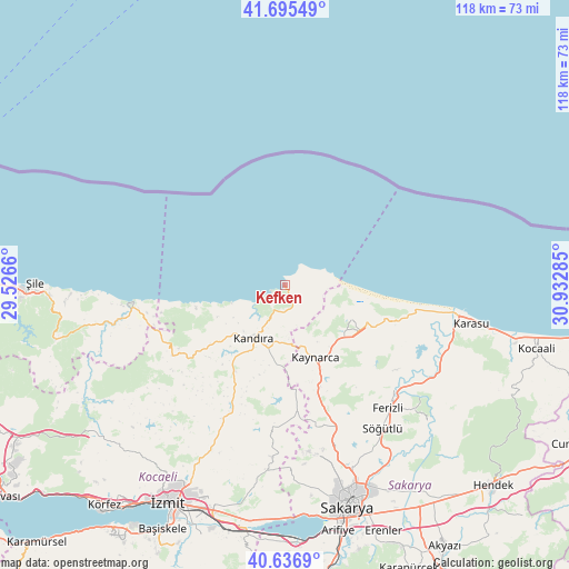
Kefken GPS coordinates[2]
41° 10' 5.988" North, 30° 13' 46.992" East
| Map corner | latitude | longitude |
|---|---|---|
| Upper-left | 41.69549°, | 29.5266° |
| Center: | 41.16833°, | 30.22972° |
| Lower-right: | 40.6369°, | 30.93285° |
| Map W x H: | 117.7×117.7 km | = 73.1×73.1mi |
| max Lat: | 42.02683° ⇑6.6% North |
| Kefken: | 41.16833° |
| min Lat: | ⇓93.4% South 35.9025° |
| min Long | Kefken | max Long |
| 25.90902° | 30.22972° | 44.60099° |
| W 25.4%⇐ | ⇒74.6% E |
Elevation
Elevation of Kefken is 25 m = 82 ft, and this is 692.4 m = 2272 ft below average elevation for this country.
| Max E: |
2682 m = 8799 ft | 92.9% |
| Avg. | 717.4 m = 2354 ft | |
| Kefken | 25 m = 82 ft | |
Min E: |
0 m = 0 ft | 7.1% |
See also: Turkey elevation on elevation.city.
Geographical zone
Kefken is located in North temperate zone (between Tropic of Cancer and the Arctic Circle). Distance of this Northern Tropic circle is 1971.6 km =1225.1 mi to South.| Distance of | km | miles | from Kefken |
|---|---|---|---|
| North Pole | 5429.6 | 3373.8 | to North |
| Arctic Circle | 2823.7 | 1754.6 | to North |
| Tropic Cancer | 1971.6 | 1225.1 | to South |
| Equator | 4577.5 | 2844.3 | to South |


Nearby cities:
15 places around Kefken: (largest is in red/bold)
• Adapazarı
45.5 km =28.3 mi,  161°
161°
• Akmeşe
35.6 km =22.1 mi,  184°
184°
• Akçaova
31.1 km =19.3 mi,  241°
241°
• Ağva
31.4 km =19.5 mi,  263°
263°
• Ferizli
33.2 km =20.6 mi,  139°
139°
• Kandıra
12.7 km =7.9 mi,  210°
210°
• Karacaköy
38.6 km =24 mi,  267°
267°
• Karasu
39.7 km =24.7 mi,  100°
100°
• Kaymas
27.4 km =17 mi,  173°
173°
• Kaynarca
16.6 km =10.3 mi, 156°
• Kazımpaşa
42.2 km =26.2 mi, 172°
• Ortaköy
43.3 km =26.9 mi,  120°
120°
• Serdivan
45.7 km =28.4 mi, 163°
• Söğütlü
35.7 km =22.2 mi, 144°
• Çat
42.8 km =26.6 mi, 236°
Sources, notices
• [Note1] Compared only with cities in Turkey existing in our database
• [Src1] Map data: © OpenStreetMap contributors (CC-BY-SA)
• [Src2] Other city data from geonames.org with taken over terms of usage.
• [Src3] Geographical zone / Annual Mean Temperature by Robert A. Rohde @ Wikipedia
