Gürpınar geodata
Gürpınar (Istanbul) is a populated place; located in Turkey in Europe/Istanbul (GMT+3) time zone. With population of 29,411 people, there are 256 cities with bigger population in this country. Compared to other cities in Turkey, 88.8% of cities are located further ↓South; 86.4% of cities are located further →East and 80.2% of cities have higher elevation than Gürpınar. Note1


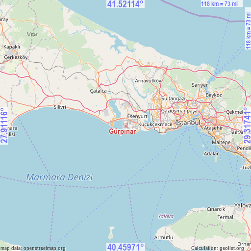
Gürpınar GPS coordinates[2]
40° 59' 33.216" North, 28° 36' 51.408" East
| Map corner | latitude | longitude |
|---|---|---|
| Upper-left | 41.52114°, | 27.91116° |
| Center: | 40.99256°, | 28.61428° |
| Lower-right: | 40.45971°, | 29.31741° |
| Map W x H: | 118×118 km | = 73.3×73.3mi |
| max Lat: | 42.02683° ⇑11.2% North |
| Gürpınar: | 40.99256° |
| min Lat: | ⇓88.8% South 35.9025° |
| min Long | Gürpınar | max Long |
| 25.90902° | 28.61428° | 44.60099° |
| W 13.6%⇐ | ⇒86.4% E |
Elevation
Elevation of Gürpınar is 113 m = 371 ft, and this is 604.4 m = 1983 ft below average elevation for this country.
| Max E: |
2682 m = 8799 ft | 80.2% |
| Avg. | 717.4 m = 2354 ft | |
| Gürpınar | 113 m = 371 ft | |
Min E: |
0 m = 0 ft | 19.8% |
See also: Turkey elevation on elevation.city.
Geographical zone
Gürpınar is located in North temperate zone (between Tropic of Cancer and the Arctic Circle). Distance of this Northern Tropic circle is 1952 km =1212.9 mi to South.| Distance of | km | miles | from Gürpınar |
|---|---|---|---|
| North Pole | 5449.1 | 3385.9 | to North |
| Arctic Circle | 2843.2 | 1766.7 | to North |
| Tropic Cancer | 1952 | 1212.9 | to South |
| Equator | 4557.9 | 2832.1 | to South |


Nearby cities:
15 places around Gürpınar: (largest is in red/bold)
• Bahçelievler
20.6 km =12.8 mi,  86°
86°
• Bağcılar
21 km =13 mi,  75°
75°
• Başakşehir
19.3 km =12 mi,  54°
54°
• Beylikdüzü
2.5 km =1.6 mi,  118°
118°
• Büyükçekmece
4 km =2.5 mi,  321°
321°
• Celâliye
17.7 km =11 mi,  291°
291°
• Chekmejeh
6.8 km =4.2 mi, 289°
• Esenyurt
6.5 km =4 mi, 54°
• Kumburgaz
11.7 km =7.3 mi, 285°
• Mahmutbey
19 km =11.8 mi,  69°
69°
• Mimarsinan
5.2 km =3.2 mi,  302°
302°
• Muratbey
15.4 km =9.6 mi, 318°
• Tepecik
6.8 km =4.2 mi,  307°
307°
• Yakuplu
5.2 km =3.2 mi, 94°
• Çatalca
21.1 km =13.1 mi, 322°
Sources, notices
• [Note1] Compared only with cities in Turkey existing in our database
• [Src1] Map data: © OpenStreetMap contributors (CC-BY-SA)
• [Src2] Other city data from geonames.org with taken over terms of usage.
• [Src3] Geographical zone / Annual Mean Temperature by Robert A. Rohde @ Wikipedia
