Muratbey geodata
Muratbey (Istanbul) is a populated place; located in Turkey in Europe/Istanbul (GMT+3) time zone. With population of 2,164 people, there are 928 cities with bigger population in this country. Compared to other cities in Turkey, 92.2% of cities are located further ↓South; 87.1% of cities are located further →East and 84.4% of cities have higher elevation than Muratbey. Note1


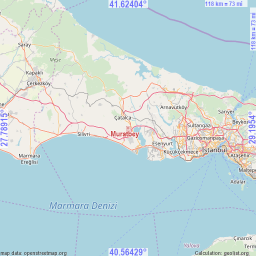
Muratbey GPS coordinates[2]
41° 5' 46.68" North, 28° 29' 32.172" East
| Map corner | latitude | longitude |
|---|---|---|
| Upper-left | 41.62404°, | 27.78915° |
| Center: | 41.0963°, | 28.49227° |
| Lower-right: | 40.56429°, | 29.1954° |
| Map W x H: | 117.8×117.8 km | = 73.2×73.2mi |
| max Lat: | 42.02683° ⇑7.8% North |
| Muratbey: | 41.0963° |
| min Lat: | ⇓92.2% South 35.9025° |
| min Long | Muratbey | max Long |
| 25.90902° | 28.49227° | 44.60099° |
| W 12.9%⇐ | ⇒87.1% E |
Elevation
Elevation of Muratbey is 76 m = 249 ft, and this is 641.4 m = 2104 ft below average elevation for this country.
| Max E: |
2682 m = 8799 ft | 84.4% |
| Avg. | 717.4 m = 2354 ft | |
| Muratbey | 76 m = 249 ft | |
Min E: |
0 m = 0 ft | 15.6% |
See also: Turkey elevation on elevation.city.
Geographical zone
Muratbey is located in North temperate zone (between Tropic of Cancer and the Arctic Circle). Distance of this Northern Tropic circle is 1963.6 km =1220.1 mi to South.| Distance of | km | miles | from Muratbey |
|---|---|---|---|
| North Pole | 5437.6 | 3378.8 | to North |
| Arctic Circle | 2831.7 | 1759.5 | to North |
| Tropic Cancer | 1963.6 | 1220.1 | to South |
| Equator | 4569.5 | 2839.4 | to South |


Nearby cities:
15 places around Muratbey: (largest is in red/bold)
• Beylikdüzü
17.7 km =11 mi,  135°
135°
• Büyükçekmece
11.4 km =7.1 mi, 137°
• Celâliye
7.9 km =4.9 mi,  231°
231°
• Chekmejeh
10 km =6.2 mi,  157°
157°
• Esenyurt
17.3 km =10.7 mi,  116°
116°
• Gürpınar
15.4 km =9.6 mi, 138°
• Kavaklı
13.5 km =8.4 mi,  268°
268°
• Kumburgaz
8.4 km =5.2 mi,  186°
186°
• Mimarsinan
10.5 km =6.5 mi,  146°
146°
• Ortaköy
9.8 km =6.1 mi, 273°
• Selimpaşa
11.5 km =7.1 mi,  246°
246°
• Silivri
20.8 km =12.9 mi,  263°
263°
• Tepecik
8.9 km =5.5 mi, 147°
• Yakuplu
19.5 km =12.1 mi,  127°
127°
• Çatalca
5.8 km =3.6 mi,  333°
333°
Sources, notices
• [Note1] Compared only with cities in Turkey existing in our database
• [Src1] Map data: © OpenStreetMap contributors (CC-BY-SA)
• [Src2] Other city data from geonames.org with taken over terms of usage.
• [Src3] Geographical zone / Annual Mean Temperature by Robert A. Rohde @ Wikipedia
