İhsangazi geodata
İhsangazi (Kastamonu) is a seat of a second-order administrative division; located in Turkey in Europe/Istanbul (GMT+3) time zone. With population of 2,957 people, there are 864 cities with bigger population in this country. Compared to other cities in Turkey, 94.1% of cities are located further ↓South; 60% of cities are located further →East and 59.1% of cities have lower elevation than İhsangazi. Note1


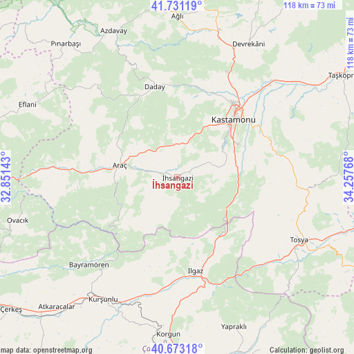
İhsangazi GPS coordinates[2]
41° 12' 15.552" North, 33° 33' 16.38" East
| Map corner | latitude | longitude |
|---|---|---|
| Upper-left | 41.73119°, | 32.85143° |
| Center: | 41.20432°, | 33.55455° |
| Lower-right: | 40.67318°, | 34.25768° |
| Map W x H: | 117.6×117.6 km | = 73.1×73.1mi |
| max Lat: | 42.02683° ⇑5.9% North |
| İhsangazi: | 41.20432° |
| min Lat: | ⇓94.1% South 35.9025° |
| min Long | İhsangazi | max Long |
| 25.90902° | 33.55455° | 44.60099° |
| W 40%⇐ | ⇒60% E |
Elevation
Elevation of İhsangazi is 868 m = 2848 ft, and this is 150.6 m = 494 ft above average elevation for this country.
| Max E: |
2682 m = 8799 ft | 40.9% |
| İhsangazi | 868 m 2848 ft | |
| Avg. | 717.4 m = 2354 ft | |
Min E: |
0 m = 0 ft | 59.1% |
See also: Turkey elevation on elevation.city.
Geographical zone
İhsangazi is located in North temperate zone (between Tropic of Cancer and the Arctic Circle). Distance of this Northern Tropic circle is 1975.6 km =1227.6 mi to South.| Distance of | km | miles | from İhsangazi |
|---|---|---|---|
| North Pole | 5425.6 | 3371.3 | to North |
| Arctic Circle | 2819.7 | 1752.1 | to North |
| Tropic Cancer | 1975.6 | 1227.6 | to South |
| Equator | 4581.5 | 2846.8 | to South |


Nearby cities:
15 places around İhsangazi: (largest is in red/bold)
• Akkaya
6.1 km =3.8 mi,  285°
285°
• Araç
19.4 km =12.1 mi,  282°
282°
• Bayramören
41.4 km =25.7 mi,  225°
225°
• Belören
38.4 km =23.9 mi,  187°
187°
• Boyalı
28.8 km =17.9 mi, 226°
• Daday
31.4 km =19.5 mi,  346°
346°
• Devrekani
50.3 km =31.3 mi,  28°
28°
• Ilgaz
31.6 km =19.6 mi,  169°
169°
• Kastamonu
26.7 km =16.6 mi,  43°
43°
• Korgun
52.3 km =32.5 mi,  183°
183°
• Kurşunlu
47.3 km =29.4 mi,  211°
211°
• Kuzyaka
14.4 km =8.9 mi,  77°
77°
• Seydiler
48.2 km =30 mi,  16°
16°
• Tosya
45.8 km =28.5 mi,  117°
117°
• İğdir
35 km =21.7 mi,  273°
273°
Sources, notices
• [Note1] Compared only with cities in Turkey existing in our database
• [Src1] Map data: © OpenStreetMap contributors (CC-BY-SA)
• [Src2] Other city data from geonames.org with taken over terms of usage.
• [Src3] Geographical zone / Annual Mean Temperature by Robert A. Rohde @ Wikipedia
