Araç geodata
Araç (Kastamonu) is a seat of a second-order administrative division; located in Turkey in Europe/Istanbul (GMT+3) time zone. With population of 5,590 people, there are 678 cities with bigger population in this country. Compared to other cities in Turkey, 95% of cities are located further ↓South; 61% of cities are located further →East and 50.9% of cities have higher elevation than Araç. Note1


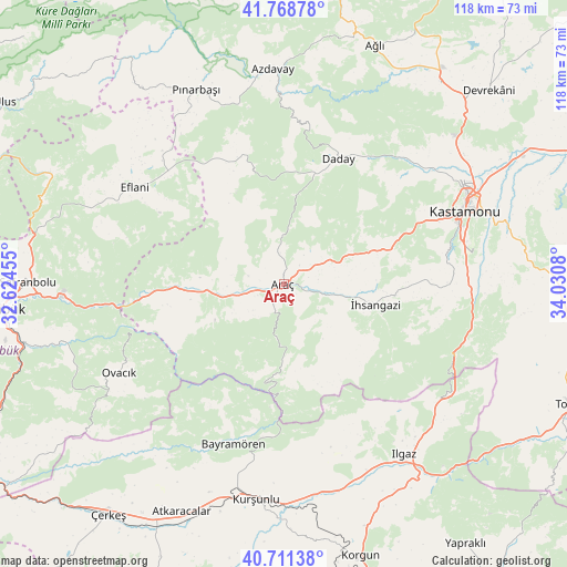
Araç GPS coordinates[2]
41° 14' 31.992" North, 33° 19' 39.612" East
| Map corner | latitude | longitude |
|---|---|---|
| Upper-left | 41.76878°, | 32.62455° |
| Center: | 41.24222°, | 33.32767° |
| Lower-right: | 40.71138°, | 34.0308° |
| Map W x H: | 117.6×117.6 km | = 73.1×73.1mi |
| max Lat: | 42.02683° ⇑5% North |
| Araç: | 41.24222° |
| min Lat: | ⇓95% South 35.9025° |
| min Long | Araç | max Long |
| 25.90902° | 33.32767° | 44.60099° |
| W 39%⇐ | ⇒61% E |
Elevation
Elevation of Araç is 675 m = 2215 ft, and this is 42.4 m = 139 ft below average elevation for this country.
| Max E: |
2682 m = 8799 ft | 50.9% |
| Avg. | 717.4 m = 2354 ft | |
| Araç | 675 m = 2215 ft | |
Min E: |
0 m = 0 ft | 49.1% |
See also: Turkey elevation on elevation.city.
Geographical zone
Araç is located in North temperate zone (between Tropic of Cancer and the Arctic Circle). Distance of this Northern Tropic circle is 1979.8 km =1230.2 mi to South.| Distance of | km | miles | from Araç |
|---|---|---|---|
| North Pole | 5421.4 | 3368.7 | to North |
| Arctic Circle | 2815.5 | 1749.5 | to North |
| Tropic Cancer | 1979.8 | 1230.2 | to South |
| Equator | 4585.7 | 2849.4 | to South |


Nearby cities:
15 places around Araç: (largest is in red/bold)
• Akkaya
13.4 km =8.3 mi,  101°
101°
• Azdavay
44.6 km =27.7 mi,  357°
357°
• Bayramören
34.8 km =21.6 mi,  197°
197°
• Belören
44.6 km =27.7 mi,  161°
161°
• Boyalı
24 km =14.9 mi,  184°
184°
• Daday
28.7 km =17.8 mi,  23°
23°
• Eflani
36.9 km =22.9 mi,  303°
303°
• Ilgaz
43.2 km =26.8 mi,  144°
144°
• Kastamonu
40.3 km =25 mi,  68°
68°
• Kurşunlu
45 km =28 mi,  187°
187°
• Kuzyaka
33 km =20.5 mi,  91°
91°
• Ovacık
38.8 km =24.1 mi,  241°
241°
• Pınarbaşı
44.1 km =27.4 mi,  335°
335°
• İhsangazi
19.4 km =12.1 mi, 102°
• İğdir
16 km =9.9 mi,  263°
263°
Sources, notices
• [Note1] Compared only with cities in Turkey existing in our database
• [Src1] Map data: © OpenStreetMap contributors (CC-BY-SA)
• [Src2] Other city data from geonames.org with taken over terms of usage.
• [Src3] Geographical zone / Annual Mean Temperature by Robert A. Rohde @ Wikipedia
