Yapraklı geodata
Yapraklı (Çankırı) is a seat of a second-order administrative division; located in Turkey in Europe/Istanbul (GMT+3) time zone. With population of 6,394 people, there are 636 cities with bigger population in this country. Compared to other cities in Turkey, 82.6% of cities are located further ↓South; 59.1% of cities are located further →East and 80.6% of cities have lower elevation than Yapraklı. Note1


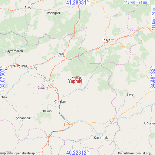
Yapraklı GPS coordinates[2]
40° 45' 28.26" North, 33° 46' 41.484" East
| Map corner | latitude | longitude |
|---|---|---|
| Upper-left | 41.28831°, | 33.07507° |
| Center: | 40.75785°, | 33.77819° |
| Lower-right: | 40.22312°, | 34.48132° |
| Map W x H: | 118.4×118.4 km | = 73.6×73.6mi |
| max Lat: | 42.02683° ⇑17.4% North |
| Yapraklı: | 40.75785° |
| min Lat: | ⇓82.6% South 35.9025° |
| min Long | Yapraklı | max Long |
| 25.90902° | 33.77819° | 44.60099° |
| W 40.9%⇐ | ⇒59.1% E |
Elevation
Elevation of Yapraklı is 1206 m = 3957 ft, and this is 488.6 m = 1603 ft above average elevation for this country.
| Max E: |
2682 m = 8799 ft | 19.4% |
| Yapraklı | 1206 m 3957 ft | |
| Avg. | 717.4 m = 2354 ft | |
Min E: |
0 m = 0 ft | 80.6% |
See also: Turkey elevation on elevation.city.
Geographical zone
Yapraklı is located in North temperate zone (between Tropic of Cancer and the Arctic Circle). Distance of this Northern Tropic circle is 1925.9 km =1196.7 mi to South.| Distance of | km | miles | from Yapraklı |
|---|---|---|---|
| North Pole | 5475.2 | 3402.1 | to North |
| Arctic Circle | 2869.3 | 1782.9 | to North |
| Tropic Cancer | 1925.9 | 1196.7 | to South |
| Equator | 4531.8 | 2815.9 | to South |


Nearby cities:
15 places around Yapraklı: (largest is in red/bold)
• Bayat
42.6 km =26.5 mi,  107°
107°
• Bayramören
52.6 km =32.7 mi,  293°
293°
• Belören
26.4 km =16.4 mi,  295°
295°
• Boyalı
49.8 km =30.9 mi,  306°
306°
• Eldivan
34.6 km =21.5 mi,  222°
222°
• Ilgaz
22.6 km =14 mi,  325°
325°
• Khanjarah
22.3 km =13.9 mi, 218°
• Korgun
22 km =13.7 mi,  263°
263°
• Kurşunlu
44.6 km =27.7 mi,  281°
281°
• Kuzyaka
52.9 km =32.9 mi,  354°
354°
• Kızılırmak
49.1 km =30.5 mi,  159°
159°
• Tosya
36.1 km =22.4 mi,  37°
37°
• İhsangazi
53.1 km =33 mi,  339°
339°
• İkizören
11.8 km =7.3 mi,  131°
131°
• Şabanözü
51.8 km =32.2 mi,  233°
233°
Sources, notices
• [Note1] Compared only with cities in Turkey existing in our database
• [Src1] Map data: © OpenStreetMap contributors (CC-BY-SA)
• [Src2] Other city data from geonames.org with taken over terms of usage.
• [Src3] Geographical zone / Annual Mean Temperature by Robert A. Rohde @ Wikipedia
