Kurşunlu geodata
Kurşunlu (Bursa) is a populated place; located in Turkey in Europe/Istanbul (GMT+3) time zone. With population of 3,461 people, there are 826 cities with bigger population in this country. Compared to other cities in Turkey, 69.7% of cities are located further ↓South; 78.1% of cities are located further →East and 69.1% of cities have higher elevation than Kurşunlu. Note1


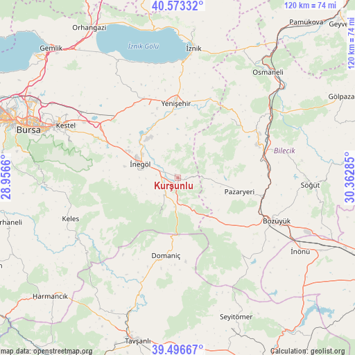
Kurşunlu GPS coordinates[2]
40° 2' 13.632" North, 29° 39' 34.992" East
| Map corner | latitude | longitude |
|---|---|---|
| Upper-left | 40.57332°, | 28.9566° |
| Center: | 40.03712°, | 29.65972° |
| Lower-right: | 39.49667°, | 30.36285° |
| Map W x H: | 119.7×119.7 km | = 74.4×74.4mi |
| max Lat: | 42.02683° ⇑30.3% North |
| Kurşunlu: | 40.03712° |
| min Lat: | ⇓69.7% South 35.9025° |
| min Long | Kurşunlu | max Long |
| 25.90902° | 29.65972° | 44.60099° |
| W 21.9%⇐ | ⇒78.1% E |
Elevation
Elevation of Kurşunlu is 331 m = 1086 ft, and this is 386.4 m = 1268 ft below average elevation for this country.
| Max E: |
2682 m = 8799 ft | 69.1% |
| Avg. | 717.4 m = 2354 ft | |
| Kurşunlu | 331 m = 1086 ft | |
Min E: |
0 m = 0 ft | 30.9% |
See also: Turkey elevation on elevation.city.
Geographical zone
Kurşunlu is located in North temperate zone (between Tropic of Cancer and the Arctic Circle). Distance of this Northern Tropic circle is 1845.8 km =1146.9 mi to South.| Distance of | km | miles | from Kurşunlu |
|---|---|---|---|
| North Pole | 5555.4 | 3452 | to North |
| Arctic Circle | 2949.5 | 1832.7 | to North |
| Tropic Cancer | 1845.8 | 1146.9 | to South |
| Equator | 4451.7 | 2766.2 | to South |


Nearby cities:
15 places around Kurşunlu: (largest is in red/bold)
• Alanyurt
14.4 km =8.9 mi,  303°
303°
• Bilecik
29.6 km =18.4 mi,  66°
66°
• Bozüyük
35.2 km =21.9 mi,  114°
114°
• Cerrah
18.5 km =11.5 mi,  281°
281°
• Dodurga
34.3 km =21.3 mi,  140°
140°
• Domaniç
26.5 km =16.5 mi,  189°
189°
• Hamzabey
15.8 km =9.8 mi,  314°
314°
• Kozluören
27.9 km =17.3 mi,  290°
290°
• Küplü
29.8 km =18.5 mi,  76°
76°
• Pazaryeri
21.4 km =13.3 mi,  102°
102°
• Tahtaköprü
9.7 km =6 mi,  184°
184°
• Yarhisar
26.9 km =16.7 mi,  41°
41°
• Yenice
21 km =13 mi, 285°
• Yenişehir
25.3 km =15.7 mi,  358°
358°
• İnegol
13.3 km =8.3 mi, 290°
Sources, notices
• [Note1] Compared only with cities in Turkey existing in our database
• [Src1] Map data: © OpenStreetMap contributors (CC-BY-SA)
• [Src2] Other city data from geonames.org with taken over terms of usage.
• [Src3] Geographical zone / Annual Mean Temperature by Robert A. Rohde @ Wikipedia
