Hamzabey geodata
Hamzabey (Bursa) is a populated place; located in Turkey in Europe/Istanbul (GMT+3) time zone. With population of 1,096 people, there are 1071 cities with bigger population in this country. Compared to other cities in Turkey, 71.5% of cities are located further ↓South; 79.3% of cities are located further →East and 70.3% of cities have higher elevation than Hamzabey. Note1


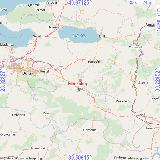
Hamzabey GPS coordinates[2]
40° 8' 8.988" North, 29° 31' 35.004" East
| Map corner | latitude | longitude |
|---|---|---|
| Upper-left | 40.67125°, | 28.82327° |
| Center: | 40.13583°, | 29.52639° |
| Lower-right: | 39.59615°, | 30.22952° |
| Map W x H: | 119.5×119.5 km | = 74.3×74.3mi |
| max Lat: | 42.02683° ⇑28.5% North |
| Hamzabey: | 40.13583° |
| min Lat: | ⇓71.5% South 35.9025° |
| min Long | Hamzabey | max Long |
| 25.90902° | 29.52639° | 44.60099° |
| W 20.7%⇐ | ⇒79.3% E |
Elevation
Elevation of Hamzabey is 286 m = 938 ft, and this is 431.4 m = 1415 ft below average elevation for this country.
| Max E: |
2682 m = 8799 ft | 70.3% |
| Avg. | 717.4 m = 2354 ft | |
| Hamzabey | 286 m = 938 ft | |
Min E: |
0 m = 0 ft | 29.7% |
See also: Turkey elevation on elevation.city.
Geographical zone
Hamzabey is located in North temperate zone (between Tropic of Cancer and the Arctic Circle). Distance of this Northern Tropic circle is 1856.8 km =1153.8 mi to South.| Distance of | km | miles | from Hamzabey |
|---|---|---|---|
| North Pole | 5544.4 | 3445.1 | to North |
| Arctic Circle | 2938.5 | 1825.9 | to North |
| Tropic Cancer | 1856.8 | 1153.8 | to South |
| Equator | 4462.7 | 2773 | to South |


Nearby cities:
15 places around Hamzabey: (largest is in red/bold)
• Alanyurt
3.1 km =1.9 mi,  192°
192°
• Balarim
27 km =16.8 mi,  11°
11°
• Cerrah
9.9 km =6.2 mi,  223°
223°
• Gölcük
20.1 km =12.5 mi,  321°
321°
• Gürsu
29.6 km =18.4 mi,  288°
288°
• Kestel
27.6 km =17.1 mi,  284°
284°
• Kozluören
14.8 km =9.2 mi,  265°
265°
• Kurşunlu
15.8 km =9.8 mi,  134°
134°
• Narlıca
28.1 km =17.5 mi,  352°
352°
• Sölöz
30.3 km =18.8 mi,  341°
341°
• Tahtaköprü
23.2 km =14.4 mi,  153°
153°
• Yarhisar
30.6 km =19 mi,  72°
72°
• Yenice
10.4 km =6.5 mi,  238°
238°
• Yenişehir
17.9 km =11.1 mi,  36°
36°
• İnegol
6.5 km =4 mi, 189°
Sources, notices
• [Note1] Compared only with cities in Turkey existing in our database
• [Src1] Map data: © OpenStreetMap contributors (CC-BY-SA)
• [Src2] Other city data from geonames.org with taken over terms of usage.
• [Src3] Geographical zone / Annual Mean Temperature by Robert A. Rohde @ Wikipedia
