Tahtaköprü geodata
Tahtaköprü (Bursa) is a seat of a third-order administrative division; located in Turkey in Europe/Istanbul (GMT+3) time zone. With population of 1,575 people, there are 1001 cities with bigger population in this country. Compared to other cities in Turkey, 68.3% of cities are located further ↓South; 78.4% of cities are located further →East and 55.5% of cities have higher elevation than Tahtaköprü. Note1


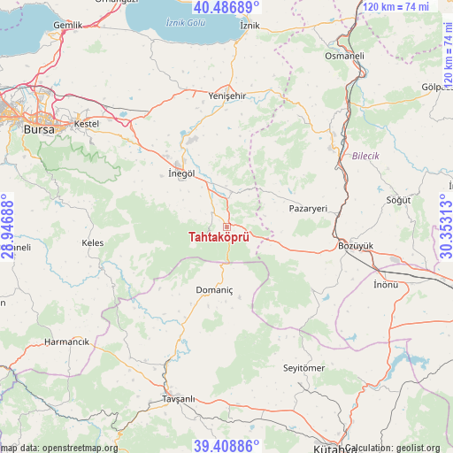
Tahtaköprü GPS coordinates[2]
39° 57' 0" North, 29° 39' 0" East
| Map corner | latitude | longitude |
|---|---|---|
| Upper-left | 40.48689°, | 28.94688° |
| Center: | 39.95°, | 29.65° |
| Lower-right: | 39.40886°, | 30.35313° |
| Map W x H: | 119.9×119.9 km | = 74.5×74.5mi |
| max Lat: | 42.02683° ⇑31.7% North |
| Tahtaköprü: | 39.95° |
| min Lat: | ⇓68.3% South 35.9025° |
| min Long | Tahtaköprü | max Long |
| 25.90902° | 29.65° | 44.60099° |
| W 21.6%⇐ | ⇒78.4% E |
Elevation
Elevation of Tahtaköprü is 578 m = 1896 ft, and this is 139.4 m = 457 ft below average elevation for this country.
| Max E: |
2682 m = 8799 ft | 55.5% |
| Avg. | 717.4 m = 2354 ft | |
| Tahtaköprü | 578 m = 1896 ft | |
Min E: |
0 m = 0 ft | 44.5% |
See also: Turkey elevation on elevation.city.
Geographical zone
Tahtaköprü is located in North temperate zone (between Tropic of Cancer and the Arctic Circle). Distance of this Northern Tropic circle is 1836.1 km =1140.9 mi to South.| Distance of | km | miles | from Tahtaköprü |
|---|---|---|---|
| North Pole | 5565 | 3457.9 | to North |
| Arctic Circle | 2959.2 | 1838.8 | to North |
| Tropic Cancer | 1836.1 | 1140.9 | to South |
| Equator | 4442 | 2760.1 | to South |


Nearby cities:
15 places around Tahtaköprü: (largest is in red/bold)
• Alanyurt
20.9 km =13 mi,  327°
327°
• Bilecik
35.2 km =21.9 mi,  52°
52°
• Bozüyük
33.3 km =20.7 mi,  98°
98°
• Cerrah
21.9 km =13.6 mi,  307°
307°
• Dodurga
28.3 km =17.6 mi,  126°
126°
• Domaniç
16.8 km =10.4 mi,  191°
191°
• Hamzabey
23.2 km =14.4 mi, 333°
• Kozluören
32 km =19.9 mi, 307°
• Kurşunlu
9.7 km =6 mi,  4°
4°
• Küplü
34.1 km =21.2 mi,  61°
61°
• Pazaryeri
22.2 km =13.8 mi,  77°
77°
• Yarhisar
35.1 km =21.8 mi,  32°
32°
• Yenice
24.7 km =15.3 mi, 308°
• Yenişehir
35 km =21.7 mi, 0°
• İnegol
18.4 km =11.4 mi,  320°
320°
Sources, notices
• [Note1] Compared only with cities in Turkey existing in our database
• [Src1] Map data: © OpenStreetMap contributors (CC-BY-SA)
• [Src2] Other city data from geonames.org with taken over terms of usage.
• [Src3] Geographical zone / Annual Mean Temperature by Robert A. Rohde @ Wikipedia
