Uzungöl geodata
Uzungöl (Trabzon) is a seat of a third-order administrative division; located in Turkey in Europe/Istanbul (GMT+3) time zone. In our database, there are 1323 cities with bigger population. Compared to other cities in Turkey, 79.3% of cities are located further ↓South; 75.4% of cities are located further ←West and 83.3% of cities have lower elevation than Uzungöl. Note1


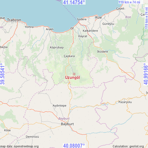
Uzungöl GPS coordinates[2]
40° 36' 57.384" North, 40° 17' 18.708" East
| Map corner | latitude | longitude |
|---|---|---|
| Upper-left | 41.14754°, | 39.58541° |
| Center: | 40.61594°, | 40.28853° |
| Lower-right: | 40.08007°, | 40.99166° |
| Map W x H: | 118.7×118.7 km | = 73.8×73.8mi |
| max Lat: | 42.02683° ⇑20.7% North |
| Uzungöl: | 40.61594° |
| min Lat: | ⇓79.3% South 35.9025° |
| min Long | Uzungöl | max Long |
| 25.90902° | 40.28853° | 44.60099° |
| W 75.4%⇐ | ⇒24.6% E |
Elevation
Elevation of Uzungöl is 1269 m = 4163 ft, and this is 551.6 m = 1810 ft above average elevation for this country.
| Max E: |
2682 m = 8799 ft | 16.7% |
| Uzungöl | 1269 m 4163 ft | |
| Avg. | 717.4 m = 2354 ft | |
Min E: |
0 m = 0 ft | 83.3% |
See also: Turkey elevation on elevation.city.
Geographical zone
Uzungöl is located in North temperate zone (between Tropic of Cancer and the Arctic Circle). Distance of this Northern Tropic circle is 1910.2 km =1186.9 mi to South.| Distance of | km | miles | from Uzungöl |
|---|---|---|---|
| North Pole | 5491 | 3411.9 | to North |
| Arctic Circle | 2885.1 | 1792.7 | to North |
| Tropic Cancer | 1910.2 | 1186.9 | to South |
| Equator | 4516.1 | 2806.2 | to South |


Nearby cities:
15 places around Uzungöl: (largest is in red/bold)
• Araklı
40.8 km =25.4 mi,  331°
331°
• Aydıntepe
28.7 km =17.8 mi,  205°
205°
• Bayburt
40.4 km =25.1 mi,  187°
187°
• Dağbaşı
34.1 km =21.2 mi,  291°
291°
• Dernekpazarı
20.4 km =12.7 mi,  349°
349°
• Güneyce
27.5 km =17.1 mi,  33°
33°
• Hayrat
30.6 km =19 mi,  12°
12°
• Kalkandere
36.1 km =22.4 mi,  20°
20°
• Köprübaşı
25.8 km =16 mi, 325°
• Küçükdere
29 km =18 mi,  317°
317°
• Of
36.2 km =22.5 mi,  356°
356°
• Sürmene
35 km =21.7 mi,  337°
337°
• Yağmurdere
36.3 km =22.6 mi,  262°
262°
• Çaykara
14.9 km =9.3 mi, 341°
• İkizdere
28.4 km =17.6 mi,  51°
51°
Sources, notices
• [Note1] Compared only with cities in Turkey existing in our database
• [Src1] Map data: © OpenStreetMap contributors (CC-BY-SA)
• [Src2] Other city data from geonames.org with taken over terms of usage.
• [Src3] Geographical zone / Annual Mean Temperature by Robert A. Rohde @ Wikipedia
