Çağlayan geodata
Çağlayan (Trabzon) is a seat of a third-order administrative division; located in Turkey in Europe/Istanbul (GMT+3) time zone. In our database, there are 1323 cities with bigger population. Compared to other cities in Turkey, 86.1% of cities are located further ↓South; 72.3% of cities are located further ←West and 77.1% of cities have higher elevation than Çağlayan. Note1


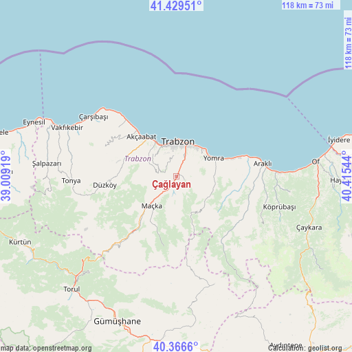
Çağlayan GPS coordinates[2]
40° 54' 0.684" North, 39° 42' 44.316" East
| Map corner | latitude | longitude |
|---|---|---|
| Upper-left | 41.42951°, | 39.00919° |
| Center: | 40.90019°, | 39.71231° |
| Lower-right: | 40.3666°, | 40.41544° |
| Map W x H: | 118.2×118.2 km | = 73.4×73.4mi |
| max Lat: | 42.02683° ⇑13.9% North |
| Çağlayan: | 40.90019° |
| min Lat: | ⇓86.1% South 35.9025° |
| min Long | Çağlayan | max Long |
| 25.90902° | 39.71231° | 44.60099° |
| W 72.3%⇐ | ⇒27.7% E |
Elevation
Elevation of Çağlayan is 150 m = 492 ft, and this is 567.4 m = 1862 ft below average elevation for this country.
| Max E: |
2682 m = 8799 ft | 77.1% |
| Avg. | 717.4 m = 2354 ft | |
| Çağlayan | 150 m = 492 ft | |
Min E: |
0 m = 0 ft | 22.9% |
See also: Turkey elevation on elevation.city.
Geographical zone
Çağlayan is located in North temperate zone (between Tropic of Cancer and the Arctic Circle). Distance of this Northern Tropic circle is 1941.8 km =1206.6 mi to South.| Distance of | km | miles | from Çağlayan |
|---|---|---|---|
| North Pole | 5459.4 | 3392.3 | to North |
| Arctic Circle | 2853.5 | 1773.1 | to North |
| Tropic Cancer | 1941.8 | 1206.6 | to South |
| Equator | 4547.7 | 2825.8 | to South |


Nearby cities:
15 places around Çağlayan: (largest is in red/bold)
• Akçaabat
17.9 km =11.1 mi,  318°
318°
• Araklı
29.4 km =18.3 mi,  81°
81°
• Arsin
18.9 km =11.7 mi,  72°
72°
• Dağbaşı
25.5 km =15.8 mi,  138°
138°
• Derecik
11.2 km =7 mi,  297°
297°
• Düzköy
25.1 km =15.6 mi,  263°
263°
• Esiroğlu
3.6 km =2.2 mi,  214°
214°
• Köprübaşı
35.4 km =22 mi,  107°
107°
• Küçükdere
30.6 km =19 mi, 109°
• Maçka
13.5 km =8.4 mi,  222°
222°
• Sürmene
34.9 km =21.7 mi,  88°
88°
• Tosköy
5.3 km =3.3 mi, 324°
• Trabzon
11.7 km =7.3 mi,  6°
6°
• Yomra
13.4 km =8.3 mi,  63°
63°
• Çarşıbaşı
34.3 km =21.3 mi,  306°
306°
Sources, notices
• [Note1] Compared only with cities in Turkey existing in our database
• [Src1] Map data: © OpenStreetMap contributors (CC-BY-SA)
• [Src2] Other city data from geonames.org with taken over terms of usage.
• [Src3] Geographical zone / Annual Mean Temperature by Robert A. Rohde @ Wikipedia
