Uğurludağ geodata
Uğurludağ (Çorum) is a seat of a second-order administrative division; located in Turkey in Europe/Istanbul (GMT+3) time zone. With population of 7,399 people, there are 600 cities with bigger population in this country. Compared to other cities in Turkey, 76.8% of cities are located further ↓South; 56.7% of cities are located further →East and 56.6% of cities have lower elevation than Uğurludağ. Note1


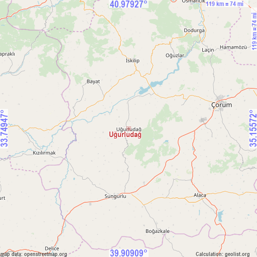
Uğurludağ GPS coordinates[2]
40° 26' 46.716" North, 34° 27' 9.324" East
| Map corner | latitude | longitude |
|---|---|---|
| Upper-left | 40.97927°, | 33.74947° |
| Center: | 40.44631°, | 34.45259° |
| Lower-right: | 39.90909°, | 35.15572° |
| Map W x H: | 119×119 km | = 73.9×73.9mi |
| max Lat: | 42.02683° ⇑23.2% North |
| Uğurludağ: | 40.44631° |
| min Lat: | ⇓76.8% South 35.9025° |
| min Long | Uğurludağ | max Long |
| 25.90902° | 34.45259° | 44.60099° |
| W 43.3%⇐ | ⇒56.7% E |
Elevation
Elevation of Uğurludağ is 821 m = 2694 ft, and this is 103.6 m = 340 ft above average elevation for this country.
| Max E: |
2682 m = 8799 ft | 43.4% |
| Uğurludağ | 821 m 2694 ft | |
| Avg. | 717.4 m = 2354 ft | |
Min E: |
0 m = 0 ft | 56.6% |
See also: Turkey elevation on elevation.city.
Geographical zone
Uğurludağ is located in North temperate zone (between Tropic of Cancer and the Arctic Circle). Distance of this Northern Tropic circle is 1891.3 km =1175.2 mi to South.| Distance of | km | miles | from Uğurludağ |
|---|---|---|---|
| North Pole | 5509.9 | 3423.7 | to North |
| Arctic Circle | 2904 | 1804.5 | to North |
| Tropic Cancer | 1891.3 | 1175.2 | to South |
| Equator | 4497.2 | 2794.4 | to South |


Nearby cities:
15 places around Uğurludağ: (largest is in red/bold)
• Alaca
45.3 km =28.1 mi,  133°
133°
• Bayat
27.4 km =17 mi,  323°
323°
• Boğazkale
49 km =30.4 mi,  164°
164°
• Cemilbey
51.9 km =32.2 mi,  102°
102°
• Dedeköy
60 km =37.3 mi,  56°
56°
• Dodurga
54.4 km =33.8 mi,  33°
33°
• Hamamözü
61.3 km =38.1 mi,  52°
52°
• Kızılırmak
41 km =25.5 mi,  254°
254°
• Laçin
51.4 km =31.9 mi,  44°
44°
• Oğuzlar
40.2 km =25 mi, 31°
• Seydim
26.4 km =16.4 mi,  65°
65°
• Sungurlu
31.7 km =19.7 mi,  192°
192°
• Çorum
43.8 km =27.2 mi, 74°
• İkizören
55.1 km =34.2 mi,  299°
299°
• İskilip
32.2 km =20 mi,  3°
3°
Sources, notices
• [Note1] Compared only with cities in Turkey existing in our database
• [Src1] Map data: © OpenStreetMap contributors (CC-BY-SA)
• [Src2] Other city data from geonames.org with taken over terms of usage.
• [Src3] Geographical zone / Annual Mean Temperature by Robert A. Rohde @ Wikipedia
