Arsin geodata
Arsin (Trabzon) is a seat of a second-order administrative division; located in Turkey in Europe/Istanbul (GMT+3) time zone. With population of 16,148 people, there are 377 cities with bigger population in this country. Compared to other cities in Turkey, 87.8% of cities are located further ↓South; 73.3% of cities are located further ←West and 95% of cities have higher elevation than Arsin. Note1


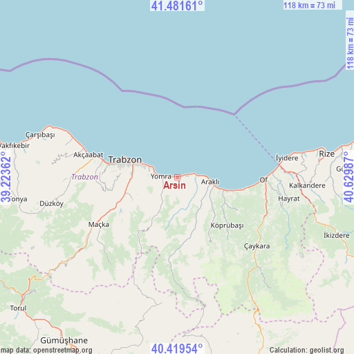
Arsin GPS coordinates[2]
40° 57' 9.756" North, 39° 55' 36.264" East
| Map corner | latitude | longitude |
|---|---|---|
| Upper-left | 41.48161°, | 39.22362° |
| Center: | 40.95271°, | 39.92674° |
| Lower-right: | 40.41954°, | 40.62987° |
| Map W x H: | 118.1×118.1 km | = 73.4×73.4mi |
| max Lat: | 42.02683° ⇑12.2% North |
| Arsin: | 40.95271° |
| min Lat: | ⇓87.8% South 35.9025° |
| min Long | Arsin | max Long |
| 25.90902° | 39.92674° | 44.60099° |
| W 73.3%⇐ | ⇒26.7% E |
Elevation
Elevation of Arsin is 16 m = 52 ft, and this is 701.4 m = 2301 ft below average elevation for this country.
| Max E: |
2682 m = 8799 ft | 95% |
| Avg. | 717.4 m = 2354 ft | |
| Arsin | 16 m = 52 ft | |
Min E: |
0 m = 0 ft | 5% |
See also: Turkey elevation on elevation.city.
Geographical zone
Arsin is located in North temperate zone (between Tropic of Cancer and the Arctic Circle). Distance of this Northern Tropic circle is 1947.6 km =1210.2 mi to South.| Distance of | km | miles | from Arsin |
|---|---|---|---|
| North Pole | 5453.5 | 3388.6 | to North |
| Arctic Circle | 2847.7 | 1769.5 | to North |
| Tropic Cancer | 1947.6 | 1210.2 | to South |
| Equator | 4553.5 | 2829.4 | to South |


Nearby cities:
15 places around Arsin: (largest is in red/bold)
• Akçaabat
30.8 km =19.1 mi,  284°
284°
• Araklı
11.2 km =7 mi,  98°
98°
• Dağbaşı
25.1 km =15.6 mi,  182°
182°
• Derecik
28 km =17.4 mi,  268°
268°
• Dernekpazarı
31.9 km =19.8 mi,  123°
123°
• Esiroğlu
21.9 km =13.6 mi,  246°
246°
• Köprübaşı
22.6 km =14 mi,  135°
135°
• Küçükdere
19.4 km =12.1 mi,  146°
146°
• Maçka
31.3 km =19.4 mi,  239°
239°
• Of
28 km =17.4 mi,  92°
92°
• Sürmene
17.7 km =11 mi,  107°
107°
• Tosköy
21.1 km =13.1 mi, 265°
• Trabzon
17.8 km =11.1 mi,  289°
289°
• Yomra
6 km =3.7 mi, 270°
• Çağlayan
18.9 km =11.7 mi, 252°
Sources, notices
• [Note1] Compared only with cities in Turkey existing in our database
• [Src1] Map data: © OpenStreetMap contributors (CC-BY-SA)
• [Src2] Other city data from geonames.org with taken over terms of usage.
• [Src3] Geographical zone / Annual Mean Temperature by Robert A. Rohde @ Wikipedia
