Tokat geodata
Tokat is a seat of a first-order administrative division; located in Turkey in Europe/Istanbul (GMT+3) time zone. With population of 129,702 people, there are 67 cities with bigger population in this country. Compared to other cities in Turkey, 74.5% of cities are located further ↓South; 55% of cities are located further ←West and 53.3% of cities have higher elevation than Tokat. Note1


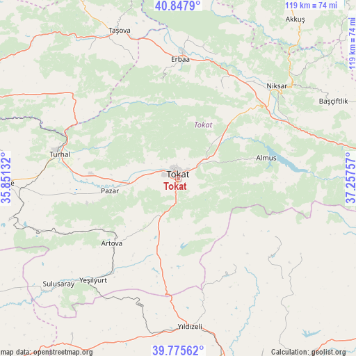
Tokat GPS coordinates[2]
40° 18' 50.004" North, 36° 33' 15.984" East
| Map corner | latitude | longitude |
|---|---|---|
| Upper-left | 40.8479°, | 35.85132° |
| Center: | 40.31389°, | 36.55444° |
| Lower-right: | 39.77562°, | 37.25757° |
| Map W x H: | 119.2×119.2 km | = 74.1×74.1mi |
| max Lat: | 42.02683° ⇑25.5% North |
| Tokat: | 40.31389° |
| min Lat: | ⇓74.5% South 35.9025° |
| min Long | Tokat | max Long |
| 25.90902° | 36.55444° | 44.60099° |
| W 55%⇐ | ⇒45% E |
Elevation
Elevation of Tokat is 627 m = 2057 ft, and this is 90.4 m = 297 ft below average elevation for this country.
| Max E: |
2682 m = 8799 ft | 53.3% |
| Avg. | 717.4 m = 2354 ft | |
| Tokat | 627 m = 2057 ft | |
Min E: |
0 m = 0 ft | 46.7% |
See also: Tokat elevation on elevation.city.
Geographical zone
Tokat is located in North temperate zone (between Tropic of Cancer and the Arctic Circle). Distance of this Northern Tropic circle is 1876.6 km =1166.1 mi to South.| Distance of | km | miles | from Tokat |
|---|---|---|---|
| North Pole | 5524.6 | 3432.8 | to North |
| Arctic Circle | 2918.7 | 1813.6 | to North |
| Tropic Cancer | 1876.6 | 1166.1 | to South |
| Equator | 4482.5 | 2785.3 | to South |


Nearby cities:
15 places around Tokat: (largest is in red/bold)
• Almus
30.4 km =18.9 mi,  76°
76°
• Artova
30.8 km =19.1 mi,  224°
224°
• Doğanyurt
43.8 km =27.2 mi,  18°
18°
• Dökmetepe
22.3 km =13.9 mi,  269°
269°
• Erbaa
39.5 km =24.5 mi,  1°
1°
• Esençay
42 km =26.1 mi,  339°
339°
• Gökdere
24.4 km =15.2 mi,  43°
43°
• Gökçeli
33.6 km =20.9 mi,  26°
26°
• Kozlu
33.4 km =20.8 mi,  348°
348°
• Pazar
23.4 km =14.5 mi,  259°
259°
• Turhal
40.9 km =25.4 mi,  281°
281°
• Yeşilyurt
17.3 km =10.7 mi, 275°
• Yeşilyurt
44.4 km =27.6 mi, 219°
• Çamlıbel
26.1 km =16.2 mi,  194°
194°
• Çırçır
34.3 km =21.3 mi,  146°
146°
Sources, notices
• [Note1] Compared only with cities in Turkey existing in our database
• [Src1] Map data: © OpenStreetMap contributors (CC-BY-SA)
• [Src2] Other city data from geonames.org with taken over terms of usage.
• [Src3] Geographical zone / Annual Mean Temperature by Robert A. Rohde @ Wikipedia
