Pingtung geodata
Pingtung (Taiwan) is a seat of a second-order administrative division; located in Taiwan in Asia/Taipei (GMT+8) time zone. In our database, there are 25 cities with bigger population. Compared to other cities in Taiwan, 89.2% of cities are located further ↑North; 67.6% of cities are located further →East and 54.1% of cities have lower elevation than Pingtung. Note1


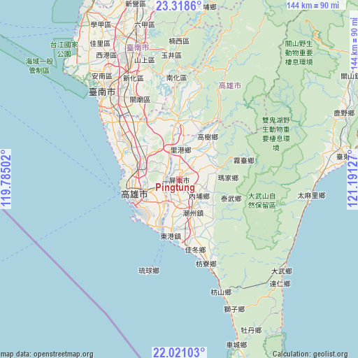
Pingtung GPS coordinates[2]
22° 40' 16.86" North, 120° 29' 17.304" East
| Map corner | latitude | longitude |
|---|---|---|
| Upper-left | 23.3186°, | 119.78502° |
| Center: | 22.67135°, | 120.48814° |
| Lower-right: | 22.02103°, | 121.19127° |
| Map W x H: | 144.3×144.3 km | = 89.7×89.7mi |
| max Lat: | 26.15039° ⇑89.2% North |
| Pingtung: | 22.67135° |
| min Lat: | ⇓10.8% South 22.00417° |
| min Long | Pingtung | max Long |
| 118.31712° | 120.48814° | 121.84424° |
| W 32.4%⇐ | ⇒67.6% E |
Elevation
Elevation of Pingtung is 32 m = 105 ft, and this is 46.5 m = 153 ft below average elevation for this country.
| Max E: |
505 m = 1657 ft | 45.9% |
| Avg. | 78.5 m = 258 ft | |
| Pingtung | 32 m = 105 ft | |
Min E: |
8 m = 26 ft | 54.1% |
See also: Taiwan elevation on elevation.city.
Geographical zone
Pingtung is located in North Torrid zone (between Equator and Tropic of Cancer). Distance of this Northern Tropic circle is 85.1 km =52.9 mi to North.| Distance of | km | miles | from Pingtung |
|---|---|---|---|
| North Pole | 7486.2 | 4651.7 | to North |
| Arctic Circle | 4880.4 | 3032.5 | to North |
| Tropic Cancer | 85.1 | 52.9 | to North |
| Equator | 2520.8 | 1566.4 | to South |


Nearby cities:
15 places around Pingtung: (largest is in red/bold)
• Donggang
23.3 km =14.5 mi,  189°
189°
• Douliu
115.6 km =71.8 mi,  2°
2°
• Fengshan
13.9 km =8.6 mi,  249°
249°
• Hengchun
78.7 km =48.9 mi,  160°
160°
• Jiayi Shi
89.9 km =55.9 mi,  357°
357°
• Kaohsiung
19 km =11.8 mi, 251°
• Lugu
122.5 km =76.1 mi,  12°
12°
• Magong
135.6 km =84.3 mi,  317°
317°
• Pizitou
90.6 km =56.3 mi, 357°
• Taibao
89.1 km =55.4 mi,  349°
349°
• Tainan
45.3 km =28.1 mi, 321°
• Taitung
68 km =42.3 mi,  81°
81°
• Taitung City
68 km =42.3 mi, 81°
• Xinying
73 km =45.4 mi, 345°
• Yujing
50.5 km =31.4 mi, 356°
In other languages:
- In Russian: Пиндун
- In Chinese: P’ing-tung-chieh, P’ing-tung-hsien, P’ing-tung-shih, P’ing-tung, 屏東市
Sources, notices
• [Note1] Compared only with cities in Taiwan existing in our database
• [Src1] Map data: © OpenStreetMap contributors (CC-BY-SA)
• [Src2] Other city data from geonames.org with taken over terms of usage.
• [Src3] Geographical zone / Annual Mean Temperature by Robert A. Rohde @ Wikipedia
