Hengchun geodata
Hengchun (Taiwan) is a seat of a third-order administrative division; located in Taiwan in Asia/Taipei (GMT+8) time zone. With population of 31,288 people, there are 19 cities with bigger population in this country. Compared to other cities in Taiwan, 100% of cities are located further ↑North; 54.1% of cities are located further ←West and 59.5% of cities have higher elevation than Hengchun. Note1


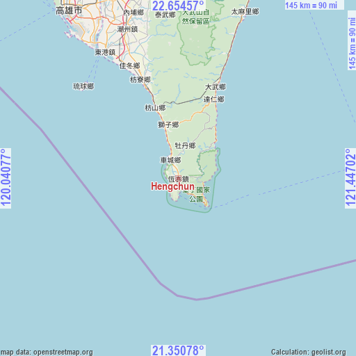
Hengchun GPS coordinates[2]
22° 0' 15.012" North, 120° 44' 38.004" East
| Map corner | latitude | longitude |
|---|---|---|
| Upper-left | 22.65457°, | 120.04077° |
| Center: | 22.00417°, | 120.74389° |
| Lower-right: | 21.35078°, | 121.44702° |
| Map W x H: | 145×145 km | = 90.1×90.1mi |
| max Lat: | 26.15039° ⇑100% North |
| Hengchun: | 22.00417° |
| min Lat: | ⇓0% South 22.00417° |
| min Long | Hengchun | max Long |
| 118.31712° | 120.74389° | 121.84424° |
| W 54.1%⇐ | ⇒45.9% E |
Elevation
Elevation of Hengchun is 25 m = 82 ft, and this is 53.5 m = 176 ft below average elevation for this country.
| Max E: |
505 m = 1657 ft | 59.5% |
| Avg. | 78.5 m = 258 ft | |
| Hengchun | 25 m = 82 ft | |
Min E: |
8 m = 26 ft | 40.5% |
See also: Taiwan elevation on elevation.city.
Geographical zone
Hengchun is located in North Torrid zone (between Equator and Tropic of Cancer). Distance of this Northern Tropic circle is 159.3 km =99 mi to North.| Distance of | km | miles | from Hengchun |
|---|---|---|---|
| North Pole | 7560.4 | 4697.8 | to North |
| Arctic Circle | 4954.5 | 3078.6 | to North |
| Tropic Cancer | 159.3 | 99 | to North |
| Equator | 2446.6 | 1520.2 | to South |


Nearby cities:
15 places around Hengchun: (largest is in red/bold)
• Donggang
59.6 km =37 mi,  329°
329°
• Douliu
190.7 km =118.5 mi,  353°
353°
• Fengshan
79.6 km =49.5 mi, 330°
• Jiayi Shi
166.8 km =103.6 mi, 349°
• Kaohsiung
81.2 km =50.5 mi, 326°
• Lugu
193.7 km =120.4 mi,  0°
0°
• Magong
210.3 km =130.7 mi, 325°
• Pingtung
78.7 km =48.9 mi,  340°
340°
• Pizitou
167.5 km =104.1 mi, 349°
• Taibao
167.2 km =103.9 mi, 345°
• Tainan
122.5 km =76.1 mi, 333°
• Taitung
93.6 km =58.2 mi,  26°
26°
• Taitung City
93.4 km =58 mi, 26°
• Xinying
151.5 km =94.1 mi, 342°
• Yujing
127.9 km =79.5 mi, 346°
Sources, notices
• [Note1] Compared only with cities in Taiwan existing in our database
• [Src1] Map data: © OpenStreetMap contributors (CC-BY-SA)
• [Src2] Other city data from geonames.org with taken over terms of usage.
• [Src3] Geographical zone / Annual Mean Temperature by Robert A. Rohde @ Wikipedia
