Mvomero geodata
Mvomero (Pwani) is a populated place; located in Tanzania in Africa/Dar_es_Salaam (GMT+3) time zone. With population of 31,324 people, there are 58 cities with bigger population in this country. Compared to other cities in Tanzania, 58.7% of cities are located further ↑North; 78.7% of cities are located further ←West and 91.6% of cities have higher elevation than Mvomero. Note1


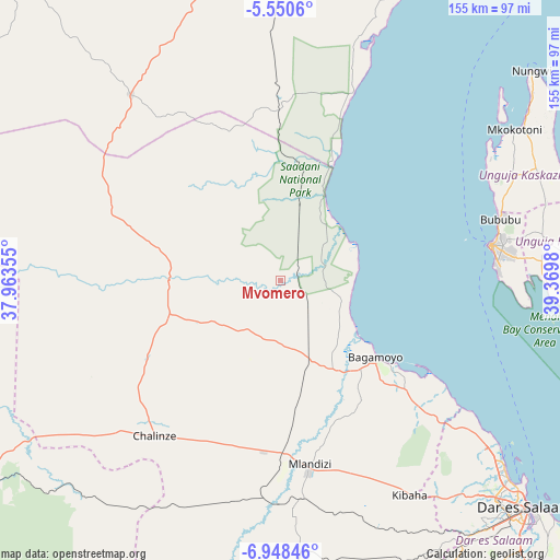
Mvomero GPS coordinates[2]
6° 15' 0" South, 38° 40' 0.012" East
| Map corner | latitude | longitude |
|---|---|---|
| Upper-left | -5.5506°, | 37.96355° |
| Center: | -6.25°, | 38.66667° |
| Lower-right: | -6.94846°, | 39.3698° |
| Map W x H: | 155.4×155.4 km | = 96.6×96.6mi |
| max Lat: | -1.14389° ⇑58.7% North |
| Mvomero: | -6.25° |
| min Lat: | ⇓41.3% South -11.36667° |
| min Long | Mvomero | max Long |
| 29.62667° | 38.66667° | 40.33333° |
| W 78.7%⇐ | ⇒21.3% E |
Elevation
Elevation of Mvomero is 34 m = 112 ft, and this is 908.8 m = 2982 ft below average elevation for this country.
| Max E: |
2377 m = 7799 ft | 91.6% |
| Avg. | 942.8 m = 3093 ft | |
| Mvomero | 34 m = 112 ft | |
Min E: |
0 m = 0 ft | 8.4% |
See also: Tanzania elevation on elevation.city.
Geographical zone
Mvomero is located in South Torrid zone (between Equator and Tropic of Capricorn). Distance of Equator is 694.9 km =431.8 mi to North.| Distance of | km | miles | from Mvomero |
|---|---|---|---|
| Equator | 694.9 | 431.8 | to North |
| Tropic Capricorn | 1911 | 1187.4 | to South |
| Antarctic Circle | 6706.2 | 4167 | to South |
| South Pole | 9312.1 | 5786.3 | to South |


Nearby cities:
15 places around Mvomero: (largest is in red/bold)
• Bagamoyo
33.9 km =21.1 mi,  129°
129°
• Chalinze
55.3 km =34.4 mi,  218°
218°
• Gamba
80.1 km =49.8 mi,  60°
60°
• Kibaha
63.7 km =39.6 mi,  154°
154°
• Kijini
84.5 km =52.5 mi, 58°
• Kisarawe
84.7 km =52.6 mi, 148°
• Kiwengwa
83.7 km =52 mi,  69°
69°
• Koani
69.4 km =43.1 mi,  79°
79°
• Koani Ndogo
69.4 km =43.1 mi, 79°
• Lugoba
43 km =26.7 mi,  238°
238°
• Magomeni
88.8 km =55.2 mi, 133°
• Mkokotoni
77.3 km =48 mi, 57°
• Mlandizi
50.6 km =31.4 mi,  171°
171°
• Ngerengere
82.4 km =51.2 mi,  227°
227°
• Zanzibar
59.5 km =37 mi, 80°
Sources, notices
• [Note1] Compared only with cities in Tanzania existing in our database
• [Src1] Map data: © OpenStreetMap contributors (CC-BY-SA)
• [Src2] Other city data from geonames.org with taken over terms of usage.
• [Src3] Geographical zone / Annual Mean Temperature by Robert A. Rohde @ Wikipedia
