Puma geodata
Puma (Singida) is a populated place; located in Tanzania in Africa/Dar_es_Salaam (GMT+3) time zone. With population of 17,092 people, there are 161 cities with bigger population in this country. Compared to other cities in Tanzania, 55.2% of cities are located further ↓South; 56.6% of cities are located further →East and 88.8% of cities have lower elevation than Puma. Note1


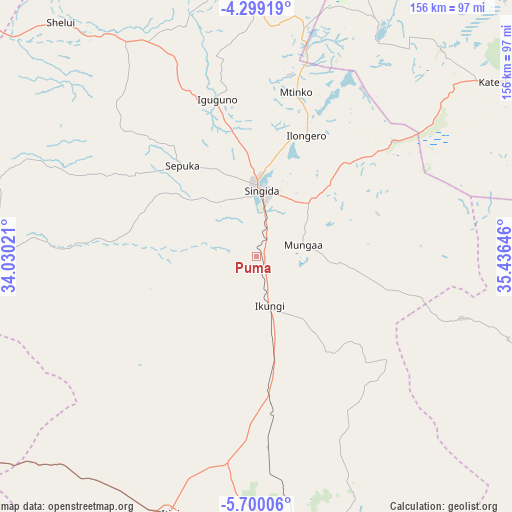
Puma GPS coordinates[2]
5° 0' 0" South, 34° 43' 59.988" East
| Map corner | latitude | longitude |
|---|---|---|
| Upper-left | -4.29919°, | 34.03021° |
| Center: | -5°, | 34.73333° |
| Lower-right: | -5.70006°, | 35.43646° |
| Map W x H: | 155.8×155.8 km | = 96.8×96.8mi |
| max Lat: | -1.14389° ⇑44.8% North |
| Puma: | -5° |
| min Lat: | ⇓55.2% South -11.36667° |
| min Long | Puma | max Long |
| 29.62667° | 34.73333° | 40.33333° |
| W 43.4%⇐ | ⇒56.6% E |
Elevation
Elevation of Puma is 1588 m = 5210 ft, and this is 645.2 m = 2117 ft above average elevation for this country.
| Max E: |
2377 m = 7799 ft | 11.2% |
| Puma | 1588 m 5210 ft | |
| Avg. | 942.8 m = 3093 ft | |
Min E: |
0 m = 0 ft | 88.8% |
See also: Tanzania elevation on elevation.city.
Geographical zone
Puma is located in South Torrid zone (between Equator and Tropic of Capricorn). Distance of Equator is 555.9 km =345.4 mi to North.| Distance of | km | miles | from Puma |
|---|---|---|---|
| Equator | 555.9 | 345.4 | to North |
| Tropic Capricorn | 2050 | 1273.8 | to South |
| Antarctic Circle | 6845.2 | 4253.4 | to South |
| South Pole | 9451.1 | 5872.6 | to South |


Nearby cities:
15 places around Puma: (largest is in red/bold)
• Basotu
80.4 km =50 mi,  28°
28°
• Igugunu
49.4 km =30.7 mi,  347°
347°
• Ikungi
15.3 km =9.5 mi,  166°
166°
• Ilongero
39.9 km =24.8 mi,  21°
21°
• Itigi
82.6 km =51.3 mi,  199°
199°
• Katesh
89.5 km =55.6 mi,  53°
53°
• Kilimatinde
97.5 km =60.6 mi, 165°
• Kiomboi
91.1 km =56.6 mi,  333°
333°
• Mtinko
51.7 km =32.1 mi,  14°
14°
• Mungaa
17 km =10.6 mi,  77°
77°
• Nangwa
99.1 km =61.6 mi, 53°
• Ndago
61.5 km =38.2 mi,  316°
316°
• Sepuka
35.5 km =22.1 mi, 321°
• Shelui
91.9 km =57.1 mi, 319°
• Singida
20.5 km =12.7 mi,  3°
3°
Sources, notices
• [Note1] Compared only with cities in Tanzania existing in our database
• [Src1] Map data: © OpenStreetMap contributors (CC-BY-SA)
• [Src2] Other city data from geonames.org with taken over terms of usage.
• [Src3] Geographical zone / Annual Mean Temperature by Robert A. Rohde @ Wikipedia
