Ndago geodata
Ndago (Singida) is a populated place; located in Tanzania in Africa/Dar_es_Salaam (GMT+3) time zone. With population of 13,012 people, there are 200 cities with bigger population in this country. Compared to other cities in Tanzania, 61.2% of cities are located further ↓South; 61.2% of cities are located further →East and 81.5% of cities have lower elevation than Ndago. Note1


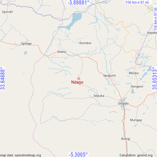
Ndago GPS coordinates[2]
4° 36' 0" South, 34° 21' 0" East
| Map corner | latitude | longitude |
|---|---|---|
| Upper-left | -3.89881°, | 33.64688° |
| Center: | -4.6°, | 34.35° |
| Lower-right: | -5.3005°, | 35.05313° |
| Map W x H: | 155.9×155.9 km | = 96.9×96.9mi |
| max Lat: | -1.14389° ⇑38.8% North |
| Ndago: | -4.6° |
| min Lat: | ⇓61.2% South -11.36667° |
| min Long | Ndago | max Long |
| 29.62667° | 34.35° | 40.33333° |
| W 38.8%⇐ | ⇒61.2% E |
Elevation
Elevation of Ndago is 1443 m = 4734 ft, and this is 500.2 m = 1641 ft above average elevation for this country.
| Max E: |
2377 m = 7799 ft | 18.5% |
| Ndago | 1443 m 4734 ft | |
| Avg. | 942.8 m = 3093 ft | |
Min E: |
0 m = 0 ft | 81.5% |
See also: Tanzania elevation on elevation.city.
Geographical zone
Ndago is located in South Torrid zone (between Equator and Tropic of Capricorn). Distance of Equator is 511.5 km =317.8 mi to North.| Distance of | km | miles | from Ndago |
|---|---|---|---|
| Equator | 511.5 | 317.8 | to North |
| Tropic Capricorn | 2094.4 | 1301.4 | to South |
| Antarctic Circle | 6889.7 | 4281.1 | to South |
| South Pole | 9495.6 | 5900.3 | to South |


Nearby cities:
15 places around Ndago: (largest is in red/bold)
• Basotu
85.3 km =53 mi,  72°
72°
• Igugunu
31.6 km =19.6 mi,  83°
83°
• Igunga
62.6 km =38.9 mi,  304°
304°
• Igurubi
98.2 km =61 mi,  312°
312°
• Ikungi
75.2 km =46.7 mi,  142°
142°
• Ilongero
57.7 km =35.9 mi,  97°
97°
• Katesh
115 km =71.5 mi,  85°
85°
• Kiomboi
37.1 km =23.1 mi,  2°
2°
• Kishapu
121.8 km =75.7 mi,  333°
333°
• Mtinko
55.7 km =34.6 mi, 84°
• Mungaa
71.8 km =44.6 mi,  124°
124°
• Puma
61.5 km =38.2 mi, 136°
• Sepuka
26.3 km =16.3 mi,  129°
129°
• Shelui
30.8 km =19.1 mi, 327°
• Singida
49.8 km =30.9 mi, 118°
Sources, notices
• [Note1] Compared only with cities in Tanzania existing in our database
• [Src1] Map data: © OpenStreetMap contributors (CC-BY-SA)
• [Src2] Other city data from geonames.org with taken over terms of usage.
• [Src3] Geographical zone / Annual Mean Temperature by Robert A. Rohde @ Wikipedia
