Mwaya geodata
Mwaya (Mbeya) is a populated place; located in Tanzania in Africa/Dar_es_Salaam (GMT+3) time zone. With population of 7,558 people, there are 258 cities with bigger population in this country. Compared to other cities in Tanzania, 86.4% of cities are located further ↑North; 66.8% of cities are located further →East and 71.7% of cities have higher elevation than Mwaya. Note1


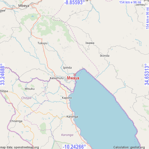
Mwaya GPS coordinates[2]
9° 33' 0" South, 33° 57' 0" East
| Map corner | latitude | longitude |
|---|---|---|
| Upper-left | -8.85593°, | 33.24688° |
| Center: | -9.55°, | 33.95° |
| Lower-right: | -10.24266°, | 34.65313° |
| Map W x H: | 154.2×154.2 km | = 95.8×95.8mi |
| max Lat: | -1.14389° ⇑86.4% North |
| Mwaya: | -9.55° |
| min Lat: | ⇓13.6% South -11.36667° |
| min Long | Mwaya | max Long |
| 29.62667° | 33.95° | 40.33333° |
| W 33.2%⇐ | ⇒66.8% E |
Elevation
Elevation of Mwaya is 479 m = 1572 ft, and this is 463.8 m = 1522 ft below average elevation for this country.
| Max E: |
2377 m = 7799 ft | 71.7% |
| Avg. | 942.8 m = 3093 ft | |
| Mwaya | 479 m = 1572 ft | |
Min E: |
0 m = 0 ft | 28.3% |
See also: Tanzania elevation on elevation.city.
Geographical zone
Mwaya is located in South Torrid zone (between Equator and Tropic of Capricorn). Distance of Equator is 1061.9 km =659.8 mi to North.| Distance of | km | miles | from Mwaya |
|---|---|---|---|
| Equator | 1061.9 | 659.8 | to North |
| Tropic Capricorn | 1544.1 | 959.5 | to South |
| Antarctic Circle | 6339.3 | 3939.1 | to South |
| South Pole | 8945.2 | 5558.3 | to South |


Nearby cities:
15 places around Mwaya: (largest is in red/bold)
• Chimala
77.6 km =48.2 mi,  6°
6°
• Igurusi
78.6 km =48.8 mi,  351°
351°
• Ilembo
70.5 km =43.8 mi,  298°
298°
• Ipinda
9.2 km =5.7 mi,  323°
323°
• Itumba
85.7 km =53.3 mi,  281°
281°
• Kandete
47.4 km =29.5 mi,  339°
339°
• Katumba
50.8 km =31.6 mi,  313°
313°
• Kiwira
61.4 km =38.2 mi, 313°
• Kyela
11.6 km =7.2 mi,  251°
251°
• Masoko
32.6 km =20.3 mi, 317°
• Matamba
63 km =39.1 mi,  1°
1°
• Mbeya
90.7 km =56.4 mi, 322°
• Mlangali
67.3 km =41.8 mi,  112°
112°
• Tukuyu
46.9 km =29.1 mi, 315°
• Ulenje
74.6 km =46.4 mi, 336°
Sources, notices
• [Note1] Compared only with cities in Tanzania existing in our database
• [Src1] Map data: © OpenStreetMap contributors (CC-BY-SA)
• [Src2] Other city data from geonames.org with taken over terms of usage.
• [Src3] Geographical zone / Annual Mean Temperature by Robert A. Rohde @ Wikipedia
