Mlangali geodata
Mlangali (Njombe) is a populated place; located in Tanzania in Africa/Dar_es_Salaam (GMT+3) time zone. With population of 15,168 people, there are 183 cities with bigger population in this country. Compared to other cities in Tanzania, 87.4% of cities are located further ↑North; 59.1% of cities are located further →East and 95.8% of cities have lower elevation than Mlangali. Note1


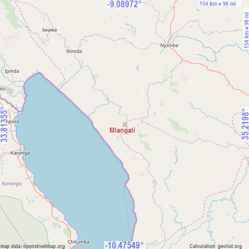
Mlangali GPS coordinates[2]
9° 46' 59.988" South, 34° 31' 0.012" East
| Map corner | latitude | longitude |
|---|---|---|
| Upper-left | -9.08972°, | 33.81355° |
| Center: | -9.78333°, | 34.51667° |
| Lower-right: | -10.47549°, | 35.2198° |
| Map W x H: | 154.1×154.1 km | = 95.8×95.8mi |
| max Lat: | -1.14389° ⇑87.4% North |
| Mlangali: | -9.78333° |
| min Lat: | ⇓12.6% South -11.36667° |
| min Long | Mlangali | max Long |
| 29.62667° | 34.51667° | 40.33333° |
| W 40.9%⇐ | ⇒59.1% E |
Elevation
Elevation of Mlangali is 1739 m = 5705 ft, and this is 796.2 m = 2612 ft above average elevation for this country.
| Max E: |
2377 m = 7799 ft | 4.2% |
| Mlangali | 1739 m 5705 ft | |
| Avg. | 942.8 m = 3093 ft | |
Min E: |
0 m = 0 ft | 95.8% |
See also: Tanzania elevation on elevation.city.
Geographical zone
Mlangali is located in South Torrid zone (between Equator and Tropic of Capricorn). Distance of Equator is 1087.8 km =675.9 mi to North.| Distance of | km | miles | from Mlangali |
|---|---|---|---|
| Equator | 1087.8 | 675.9 | to North |
| Tropic Capricorn | 1518.1 | 943.3 | to South |
| Antarctic Circle | 6313.4 | 3923 | to South |
| South Pole | 8919.3 | 5542.2 | to South |


Nearby cities:
15 places around Mlangali: (largest is in red/bold)
• Ilembula
98.5 km =61.2 mi,  4°
4°
• Ipinda
75.4 km =46.9 mi,  296°
296°
• Kandete
105.5 km =65.6 mi,  311°
311°
• Katumba
116.1 km =72.1 mi, 301°
• Kyela
76.4 km =47.5 mi,  286°
286°
• Mahanje
91 km =56.5 mi,  100°
100°
• Makumbako
109.4 km =68 mi,  18°
18°
• Manda
76.3 km =47.4 mi,  174°
174°
• Masoko
97.8 km =60.8 mi, 300°
• Matamba
107.5 km =66.8 mi,  325°
325°
• Matiri
115.4 km =71.7 mi,  158°
158°
• Mtwango
90.7 km =56.4 mi, 20°
• Mwaya
67.3 km =41.8 mi, 292°
• Njombe
55.8 km =34.7 mi,  30°
30°
• Tukuyu
112 km =69.6 mi, 301°
Sources, notices
• [Note1] Compared only with cities in Tanzania existing in our database
• [Src1] Map data: © OpenStreetMap contributors (CC-BY-SA)
• [Src2] Other city data from geonames.org with taken over terms of usage.
• [Src3] Geographical zone / Annual Mean Temperature by Robert A. Rohde @ Wikipedia
